England geodata
England (Arkansas) is a populated place; located in United States in America/Chicago (GMT-5) time zone. With population of 2,765 people, there are 10052 cities with bigger population in this country. Compared to other cities in United States, 77.5% of cities are located further ↑North; 64% of cities are located further →East and 74.6% of cities have higher elevation than England. Note1


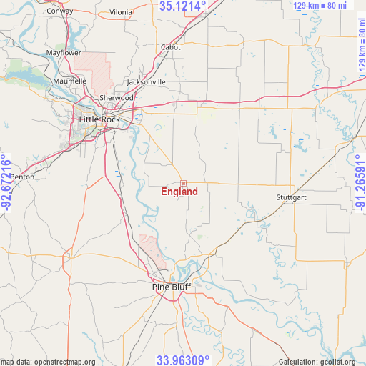
England GPS coordinates[2]
34° 32' 39.336" North, 91° 58' 8.508" West
| Map corner | latitude | longitude |
|---|---|---|
| Upper-left | 35.1214°, | -92.67216° |
| Center: | 34.54426°, | -91.96903° |
| Lower-right: | 33.96309°, | -91.26591° |
| Map W x H: | 128.8×128.8 km | = 80×80mi |
| max Lat: | 71.29058° ⇑77.5% North |
| England: | 34.54426° |
| min Lat: | ⇓22.5% South 19.06759° |
| min Long | England | max Long |
| -171.73463° | -91.96903° | -66.98998° |
| W 36%⇐ | ⇒64% E |
Elevation
Elevation of England is 74 m = 243 ft, and this is 220.8 m = 724 ft below average elevation for this country.
| Max E: |
3189 m = 10463 ft | 74.6% |
| Avg. | 294.8 m = 967 ft | |
| England | 74 m = 243 ft | |
Min E: |
-60 m = -197 ft | 25.4% |
See also: United States elevation on elevation.city.
Geographical zone
England is located in North temperate zone (between Tropic of Cancer and the Arctic Circle). Distance of this Northern Tropic circle is 1235 km =767.4 mi to South.| Distance of | km | miles | from England |
|---|---|---|---|
| North Pole | 6166.1 | 3831.4 | to North |
| Arctic Circle | 3560.2 | 2212.2 | to North |
| Tropic Cancer | 1235 | 767.4 | to South |
| Equator | 3841 | 2386.7 | to South |


Nearby cities:
15 places around England: (largest is in red/bold)
• Altheimer
27.4 km =17 mi,  155°
155°
• Carlisle
33.5 km =20.8 mi,  37°
37°
• College Station
29.4 km =18.3 mi,  308°
308°
• East End
34.1 km =21.2 mi,  271°
271°
• Humphrey
27.7 km =17.2 mi,  119°
119°
• Landmark
32.9 km =20.4 mi,  283°
283°
• Little Rock
37 km =23 mi, 307°
• Lonoke
27.4 km =17 mi,  13°
13°
• McAlmont
35.2 km =21.9 mi,  326°
326°
• North Little Rock
37 km =23 mi, 312°
• Pine Bluff
35.3 km =21.9 mi,  185°
185°
• Redfield
22.5 km =14 mi,  240°
240°
• Sweet Home
29.6 km =18.4 mi,  302°
302°
• White Hall
32.1 km =19.9 mi,  200°
200°
• Wrightsville
23.6 km =14.7 mi,  285°
285°
Sources, notices
• [Note1] Compared only with cities in United States existing in our database
• [Src1] Map data: © OpenStreetMap contributors (CC-BY-SA)
• [Src2] Other city data from geonames.org with taken over terms of usage.
• [Src3] Geographical zone / Annual Mean Temperature by Robert A. Rohde @ Wikipedia
