Altheimer geodata
Altheimer (Arkansas) is a populated place; located in United States in America/Chicago (GMT-5) time zone. With population of 894 people, there are 17018 cities with bigger population in this country. Compared to other cities in United States, 78.4% of cities are located further ↑North; 63.8% of cities are located further →East and 75.8% of cities have higher elevation than Altheimer. Note1
Administrative division(s):
- Level 1: Arkansas
- Level 2: Jefferson County
- Level 3: Township of Plum Bayou


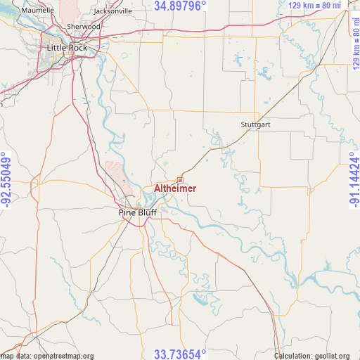
Altheimer GPS coordinates[2]
34° 19' 9.336" North, 91° 50' 50.496" West
| Map corner | latitude | longitude |
|---|---|---|
| Upper-left | 34.89796°, | -92.55049° |
| Center: | 34.31926°, | -91.84736° |
| Lower-right: | 33.73654°, | -91.14424° |
| Map W x H: | 129.1×129.1 km | = 80.2×80.2mi |
| max Lat: | 71.29058° ⇑78.4% North |
| Altheimer: | 34.31926° |
| min Lat: | ⇓21.6% South 19.06759° |
| min Long | Altheimer | max Long |
| -171.73463° | -91.84736° | -66.98998° |
| W 36.2%⇐ | ⇒63.8% E |
Elevation
Elevation of Altheimer is 67 m = 220 ft, and this is 227.8 m = 747 ft below average elevation for this country.
| Max E: |
3189 m = 10463 ft | 75.8% |
| Avg. | 294.8 m = 967 ft | |
| Altheimer | 67 m = 220 ft | |
Min E: |
-60 m = -197 ft | 24.2% |
See also: United States elevation on elevation.city.
Geographical zone
Altheimer is located in North temperate zone (between Tropic of Cancer and the Arctic Circle). Distance of this Northern Tropic circle is 1210 km =751.9 mi to South.| Distance of | km | miles | from Altheimer |
|---|---|---|---|
| North Pole | 6191.1 | 3847 | to North |
| Arctic Circle | 3585.2 | 2227.7 | to North |
| Tropic Cancer | 1210 | 751.9 | to South |
| Equator | 3815.9 | 2371.1 | to South |


Nearby cities:
15 places around Altheimer: (largest is in red/bold)
• De Witt
46.9 km =29.1 mi,  93°
93°
• England
27.4 km =17 mi,  335°
335°
• Gillett
48.8 km =30.3 mi,  117°
117°
• Gould
45.6 km =28.3 mi,  144°
144°
• Humphrey
17.3 km =10.7 mi,  48°
48°
• Lonoke
51.9 km =32.2 mi,  354°
354°
• Pine Bluff
17.5 km =10.9 mi,  234°
234°
• Redfield
33.8 km =21 mi,  294°
294°
• Rison
51 km =31.7 mi,  218°
218°
• Sheridan
50.9 km =31.6 mi,  268°
268°
• Star City
41.9 km =26 mi,  179°
179°
• Stuttgart
33.7 km =20.9 mi, 53°
• Sulphur Springs
29.7 km =18.5 mi,  238°
238°
• White Hall
22.9 km =14.2 mi,  257°
257°
• Wrightsville
46.2 km =28.7 mi,  312°
312°
Sources, notices
• [Note1] Compared only with cities in United States existing in our database
• [Src1] Map data: © OpenStreetMap contributors (CC-BY-SA)
• [Src2] Other city data from geonames.org with taken over terms of usage.
• [Src3] Geographical zone / Annual Mean Temperature by Robert A. Rohde @ Wikipedia
