Manila geodata
Manila (Arkansas) is a populated place; located in United States in America/Chicago (GMT-5) time zone. With population of 3,257 people, there are 9214 cities with bigger population in this country. Compared to other cities in United States, 71% of cities are located further ↑North; 59.5% of cities are located further →East and 74.7% of cities have higher elevation than Manila. Note1
Administrative division(s):
- Level 1: Arkansas
- Level 2: Mississippi County
- Level 3: Township of Big Lake


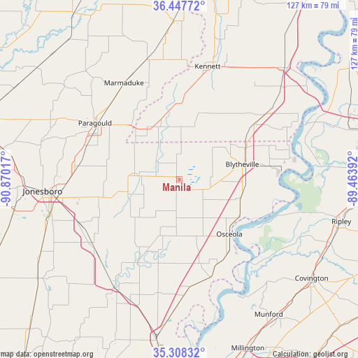
Manila GPS coordinates[2]
35° 52' 48.252" North, 90° 10' 1.344" West
| Map corner | latitude | longitude |
|---|---|---|
| Upper-left | 36.44772°, | -90.87017° |
| Center: | 35.88007°, | -90.16704° |
| Lower-right: | 35.30832°, | -89.46392° |
| Map W x H: | 126.7×126.7 km | = 78.7×78.7mi |
| max Lat: | 71.29058° ⇑71% North |
| Manila: | 35.88007° |
| min Lat: | ⇓29% South 19.06759° |
| min Long | Manila | max Long |
| -171.73463° | -90.16704° | -66.98998° |
| W 40.5%⇐ | ⇒59.5% E |
Elevation
Elevation of Manila is 73 m = 240 ft, and this is 221.8 m = 728 ft below average elevation for this country.
| Max E: |
3189 m = 10463 ft | 74.7% |
| Avg. | 294.8 m = 967 ft | |
| Manila | 73 m = 240 ft | |
Min E: |
-60 m = -197 ft | 25.3% |
See also: United States elevation on elevation.city.
Geographical zone
Manila is located in North temperate zone (between Tropic of Cancer and the Arctic Circle). Distance of this Northern Tropic circle is 1383.6 km =859.7 mi to South.| Distance of | km | miles | from Manila |
|---|---|---|---|
| North Pole | 6017.6 | 3739.2 | to North |
| Arctic Circle | 3411.7 | 2119.9 | to North |
| Tropic Cancer | 1383.6 | 859.7 | to South |
| Equator | 3989.5 | 2479 | to South |


Nearby cities:
15 places around Manila: (largest is in red/bold)
• Blytheville
23 km =14.3 mi,  76°
76°
• Caraway
19.5 km =12.1 mi,  225°
225°
• Cardwell
21.7 km =13.5 mi,  328°
328°
• Gosnell
19.7 km =12.2 mi,  63°
63°
• Hornersville
18.6 km =11.6 mi,  14°
14°
• Keiser
23.6 km =14.7 mi,  165°
165°
• Lake City
25.1 km =15.6 mi,  253°
253°
• Leachville
10.3 km =6.4 mi,  307°
307°
• Lepanto
33.3 km =20.7 mi,  206°
206°
• Luxora
25.6 km =15.9 mi,  122°
122°
• Monette
16 km =9.9 mi,  274°
274°
• Osceola
26.4 km =16.4 mi,  137°
137°
• Paragould
35.7 km =22.2 mi,  303°
303°
• Senath
28.3 km =17.6 mi,  1°
1°
• Wilson
36.5 km =22.7 mi,  161°
161°
Sources, notices
• [Note1] Compared only with cities in United States existing in our database
• [Src1] Map data: © OpenStreetMap contributors (CC-BY-SA)
• [Src2] Other city data from geonames.org with taken over terms of usage.
• [Src3] Geographical zone / Annual Mean Temperature by Robert A. Rohde @ Wikipedia
