Washington, D.C. geodata
Washington, D.C. is a capital of a political entity; located in United States in America/New_York (GMT-4) time zone. With population of 601,723 people, there are 32 cities with bigger population in this country. Compared to other cities in United States, 55.9% of cities are located further ↑North; 80.4% of cities are located further ←West and 97.4% of cities have higher elevation than Washington, D.C.. Note1


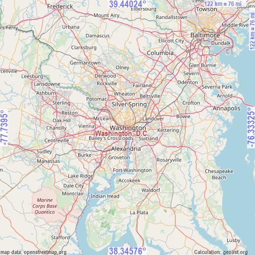
Washington, D.C. GPS coordinates[2]
38° 53' 42.396" North, 77° 2' 10.932" West
| Map corner | latitude | longitude |
|---|---|---|
| Upper-left | 39.44024°, | -77.7395° |
| Center: | 38.89511°, | -77.03637° |
| Lower-right: | 38.34576°, | -76.33325° |
| Map W x H: | 121.7×121.7 km | = 75.6×75.6mi |
| max Lat: | 71.29058° ⇑55.9% North |
| Washington, D.C.: | 38.89511° |
| min Lat: | ⇓44.1% South 19.06759° |
| min Long | Washington, D.C | max Long |
| -171.73463° | -77.03637° | -66.98998° |
| W 80.4%⇐ | ⇒19.6% E |
Elevation
Elevation of Washington, D.C. is 6 m = 20 ft, and this is 288.8 m = 948 ft below average elevation for this country.
| Max E: |
3189 m = 10463 ft | 97.4% |
| Avg. | 294.8 m = 967 ft | |
| Washington, D.C. | 6 m = 20 ft | |
Min E: |
-60 m = -197 ft | 2.6% |
See also: Washington, D.C. elevation on elevation.city.
Geographical zone
Washington, D.C. is located in North temperate zone (between Tropic of Cancer and the Arctic Circle). Distance of this Northern Tropic circle is 1718.8 km =1068 mi to South.| Distance of | km | miles | from Washington, D.C. |
|---|---|---|---|
| North Pole | 5682.3 | 3530.8 | to North |
| Arctic Circle | 3076.4 | 1911.6 | to North |
| Tropic Cancer | 1718.8 | 1068 | to South |
| Equator | 4324.7 | 2687.2 | to South |


Nearby cities:
15 places around Washington, D.C.: (largest is in red/bold)
• Adams Morgan
3 km =1.9 mi,  350°
350°
• Arlington
6.1 km =3.8 mi,  255°
255°
• Bloomingdale
3.2 km =2 mi,  41°
41°
• Brentwood
8.7 km =5.4 mi,  52°
52°
• Brookmont
8.9 km =5.5 mi,  305°
305°
• Chevy Chase
8.1 km =5 mi,  340°
340°
• Chevy Chase Village
9 km =5.6 mi, 335°
• Chillum
8.6 km =5.3 mi,  27°
27°
• Colmar Manor
8.9 km =5.5 mi,  61°
61°
• Cottage City
9 km =5.6 mi, 57°
• Friendship Village
8.8 km =5.5 mi,  328°
328°
• Mount Rainier
8 km =5 mi, 50°
• Queenstown
8.8 km =5.5 mi, 45°
• Rosslyn
3.1 km =1.9 mi,  273°
273°
• Shaw
2.3 km =1.4 mi, 34°
In other languages:
- In Spanish: Washington
- In France: Washington
- In German: Washington
- In Italian: Washington
- In Russian: Вашингтон
- In Chinese: 华盛顿特区
Sources, notices
• [Note1] Compared only with cities in United States existing in our database
• [Src1] Map data: © OpenStreetMap contributors (CC-BY-SA)
• [Src2] Other city data from geonames.org with taken over terms of usage.
• [Src3] Geographical zone / Annual Mean Temperature by Robert A. Rohde @ Wikipedia
