Christmas geodata
Christmas (Florida) is a populated place; located in United States in America/New_York (GMT-4) time zone. With population of 1,146 people, there are 15402 cities with bigger population in this country. Compared to other cities in United States, 95.9% of cities are located further ↑North; 69.4% of cities are located further ←West and 89.5% of cities have higher elevation than Christmas. Note1


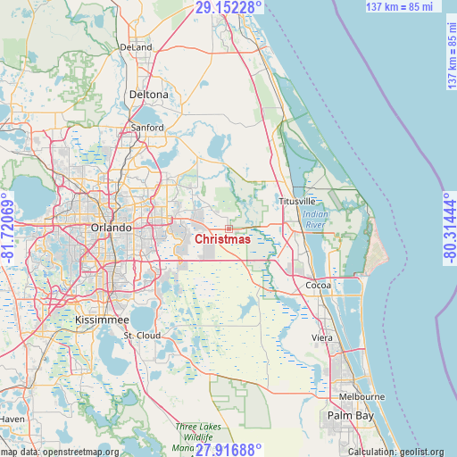
Christmas GPS coordinates[2]
28° 32' 11.004" North, 81° 1' 3.216" West
| Map corner | latitude | longitude |
|---|---|---|
| Upper-left | 29.15228°, | -81.72069° |
| Center: | 28.53639°, | -81.01756° |
| Lower-right: | 27.91688°, | -80.31444° |
| Map W x H: | 137.4×137.4 km | = 85.4×85.4mi |
| max Lat: | 71.29058° ⇑95.9% North |
| Christmas: | 28.53639° |
| min Lat: | ⇓4.1% South 19.06759° |
| min Long | Christmas | max Long |
| -171.73463° | -81.01756° | -66.98998° |
| W 69.4%⇐ | ⇒30.6% E |
Elevation
Elevation of Christmas is 17 m = 56 ft, and this is 277.8 m = 911 ft below average elevation for this country.
| Max E: |
3189 m = 10463 ft | 89.5% |
| Avg. | 294.8 m = 967 ft | |
| Christmas | 17 m = 56 ft | |
Min E: |
-60 m = -197 ft | 10.5% |
See also: United States elevation on elevation.city.
Geographical zone
Christmas is located in North temperate zone (between Tropic of Cancer and the Arctic Circle). Distance of this Northern Tropic circle is 567 km =352.3 mi to South.| Distance of | km | miles | from Christmas |
|---|---|---|---|
| North Pole | 6834.1 | 4246.5 | to North |
| Arctic Circle | 4228.2 | 2627.3 | to North |
| Tropic Cancer | 567 | 352.3 | to South |
| Equator | 3172.9 | 1971.5 | to South |


Nearby cities:
15 places around Christmas: (largest is in red/bold)
• Alafaya
19.2 km =11.9 mi,  279°
279°
• Azalea Park
27.7 km =17.2 mi,  271°
271°
• Bithlo
8.9 km =5.5 mi, 283°
• Chuluota
15.6 km =9.7 mi,  318°
318°
• Conway
30.8 km =19.1 mi,  263°
263°
• Geneva
24.5 km =15.2 mi,  337°
337°
• Goldenrod
27.7 km =17.2 mi,  287°
287°
• Lake Hart
27 km =16.8 mi,  233°
233°
• Mims
22.1 km =13.7 mi,  49°
49°
• Oviedo
23.8 km =14.8 mi,  308°
308°
• Port Saint John
23.3 km =14.5 mi,  106°
106°
• Sharpes
27.7 km =17.2 mi, 114°
• Titusville
22.2 km =13.8 mi,  67°
67°
• Union Park
26.5 km =16.5 mi, 277°
• Wedgefield
8 km =5 mi, 227°
Sources, notices
• [Note1] Compared only with cities in United States existing in our database
• [Src1] Map data: © OpenStreetMap contributors (CC-BY-SA)
• [Src2] Other city data from geonames.org with taken over terms of usage.
• [Src3] Geographical zone / Annual Mean Temperature by Robert A. Rohde @ Wikipedia
