Mims geodata
Mims (Florida) is a populated place; located in United States in America/New_York (GMT-4) time zone. With population of 7,058 people, there are 5776 cities with bigger population in this country. Compared to other cities in United States, 95.7% of cities are located further ↑North; 69.8% of cities are located further ←West and 90.5% of cities have higher elevation than Mims. Note1


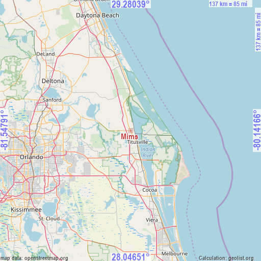
Mims GPS coordinates[2]
28° 39' 54.972" North, 80° 50' 41.208" West
| Map corner | latitude | longitude |
|---|---|---|
| Upper-left | 29.28039°, | -81.54791° |
| Center: | 28.66527°, | -80.84478° |
| Lower-right: | 28.04651°, | -80.14166° |
| Map W x H: | 137.2×137.2 km | = 85.3×85.3mi |
| max Lat: | 71.29058° ⇑95.7% North |
| Mims: | 28.66527° |
| min Lat: | ⇓4.3% South 19.06759° |
| min Long | Mims | max Long |
| -171.73463° | -80.84478° | -66.98998° |
| W 69.8%⇐ | ⇒30.2% E |
Elevation
Elevation of Mims is 15 m = 49 ft, and this is 279.8 m = 918 ft below average elevation for this country.
| Max E: |
3189 m = 10463 ft | 90.5% |
| Avg. | 294.8 m = 967 ft | |
| Mims | 15 m = 49 ft | |
Min E: |
-60 m = -197 ft | 9.5% |
See also: United States elevation on elevation.city.
Geographical zone
Mims is located in North temperate zone (between Tropic of Cancer and the Arctic Circle). Distance of this Northern Tropic circle is 581.4 km =361.3 mi to South.| Distance of | km | miles | from Mims |
|---|---|---|---|
| North Pole | 6819.8 | 4237.6 | to North |
| Arctic Circle | 4213.9 | 2618.4 | to North |
| Tropic Cancer | 581.4 | 361.3 | to South |
| Equator | 3187.3 | 1980.5 | to South |


Nearby cities:
15 places around Mims: (largest is in red/bold)
• Bithlo
28.3 km =17.6 mi,  244°
244°
• Christmas
22.1 km =13.7 mi,  229°
229°
• Chuluota
27.3 km =17 mi,  264°
264°
• Cocoa
32.6 km =20.3 mi,  162°
162°
• Cocoa West
34.8 km =21.6 mi,  168°
168°
• Edgewater
36.4 km =22.6 mi,  351°
351°
• Geneva
27.6 km =17.1 mi,  287°
287°
• Merritt Island
21.9 km =13.6 mi,  129°
129°
• Oak Hill
22.2 km =13.8 mi,  357°
357°
• Oviedo
35.5 km =22.1 mi,  270°
270°
• Port Saint John
21.6 km =13.4 mi, 165°
• Rockledge
36.9 km =22.9 mi, 161°
• Sharpes
27.2 km =16.9 mi, 162°
• Titusville
6.9 km =4.3 mi,  148°
148°
• Wedgefield
30.1 km =18.7 mi, 229°
Sources, notices
• [Note1] Compared only with cities in United States existing in our database
• [Src1] Map data: © OpenStreetMap contributors (CC-BY-SA)
• [Src2] Other city data from geonames.org with taken over terms of usage.
• [Src3] Geographical zone / Annual Mean Temperature by Robert A. Rohde @ Wikipedia
