Largo geodata
Largo (Florida) is a populated place; located in United States in America/New_York (GMT-4) time zone. With population of 81,000 people, there are 486 cities with bigger population in this country. Compared to other cities in United States, 96.8% of cities are located further ↑North; 62.6% of cities are located further ←West and 89.5% of cities have higher elevation than Largo. Note1


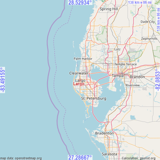
Largo GPS coordinates[2]
27° 54' 35.244" North, 82° 47' 18.312" West
| Map corner | latitude | longitude |
|---|---|---|
| Upper-left | 28.52934°, | -83.49155° |
| Center: | 27.90979°, | -82.78842° |
| Lower-right: | 27.28667°, | -82.0853° |
| Map W x H: | 138.2×138.2 km | = 85.9×85.9mi |
| max Lat: | 71.29058° ⇑96.8% North |
| Largo: | 27.90979° |
| min Lat: | ⇓3.2% South 19.06759° |
| min Long | Largo | max Long |
| -171.73463° | -82.78842° | -66.98998° |
| W 62.6%⇐ | ⇒37.4% E |
Elevation
Elevation of Largo is 17 m = 56 ft, and this is 277.8 m = 911 ft below average elevation for this country.
| Max E: |
3189 m = 10463 ft | 89.5% |
| Avg. | 294.8 m = 967 ft | |
| Largo | 17 m = 56 ft | |
Min E: |
-60 m = -197 ft | 10.5% |
See also: Largo elevation on elevation.city.
Geographical zone
Largo is located in North temperate zone (between Tropic of Cancer and the Arctic Circle). Distance of this Northern Tropic circle is 497.4 km =309.1 mi to South.| Distance of | km | miles | from Largo |
|---|---|---|---|
| North Pole | 6903.8 | 4289.8 | to North |
| Arctic Circle | 4297.9 | 2670.6 | to North |
| Tropic Cancer | 497.4 | 309.1 | to South |
| Equator | 3103.3 | 1928.3 | to South |


Nearby cities:
15 places around Largo: (largest is in red/bold)
• Bay Pines
10.7 km =6.6 mi,  174°
174°
• Belleair
3.4 km =2.1 mi,  328°
328°
• Belleair Beach
5.6 km =3.5 mi,  285°
285°
• Belleair Bluffs
3.1 km =1.9 mi, 294°
• Clearwater
6.3 km =3.9 mi,  349°
349°
• Feather Sound
11.3 km =7 mi,  95°
95°
• Harbor Bluffs
3.8 km =2.4 mi,  269°
269°
• Indian Rocks Beach
7.3 km =4.5 mi,  238°
238°
• Indian Shores
7.9 km =4.9 mi,  228°
228°
• North Redington Beach
10.9 km =6.8 mi,  196°
196°
• Pinellas Park
11.5 km =7.1 mi,  130°
130°
• Redington Shores
10.1 km =6.3 mi, 203°
• Ridgecrest
2.1 km =1.3 mi, 230°
• Seminole
7.8 km =4.8 mi,  182°
182°
• South Highpoint
7.5 km =4.7 mi,  83°
83°
Sources, notices
• [Note1] Compared only with cities in United States existing in our database
• [Src1] Map data: © OpenStreetMap contributors (CC-BY-SA)
• [Src2] Other city data from geonames.org with taken over terms of usage.
• [Src3] Geographical zone / Annual Mean Temperature by Robert A. Rohde @ Wikipedia
