Cypress Gardens geodata
Cypress Gardens (Florida) is a populated place; located in United States in America/New_York (GMT-4) time zone. With population of 8,917 people, there are 4835 cities with bigger population in this country. Compared to other cities in United States, 96.7% of cities are located further ↑North; 66.7% of cities are located further ←West and 78.2% of cities have higher elevation than Cypress Gardens. Note1


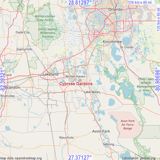
Cypress Gardens GPS coordinates[2]
27° 59' 38.076" North, 81° 41' 24.288" West
| Map corner | latitude | longitude |
|---|---|---|
| Upper-left | 28.61297°, | -82.39321° |
| Center: | 27.99391°, | -81.69008° |
| Lower-right: | 27.37127°, | -80.98696° |
| Map W x H: | 138.1×138.1 km | = 85.8×85.8mi |
| max Lat: | 71.29058° ⇑96.7% North |
| Cypress Gardens: | 27.99391° |
| min Lat: | ⇓3.3% South 19.06759° |
| min Long | Cypress Gardens | max Long |
| -171.73463° | -81.69008° | -66.98998° |
| W 66.7%⇐ | ⇒33.3% E |
Elevation
Elevation of Cypress Gardens is 55 m = 180 ft, and this is 239.8 m = 787 ft below average elevation for this country.
| Max E: |
3189 m = 10463 ft | 78.2% |
| Avg. | 294.8 m = 967 ft | |
| Cypress Gardens | 55 m = 180 ft | |
Min E: |
-60 m = -197 ft | 21.8% |
See also: United States elevation on elevation.city.
Geographical zone
Cypress Gardens is located in North temperate zone (between Tropic of Cancer and the Arctic Circle). Distance of this Northern Tropic circle is 506.7 km =314.8 mi to South.| Distance of | km | miles | from Cypress Gardens |
|---|---|---|---|
| North Pole | 6894.4 | 4284 | to North |
| Arctic Circle | 4288.5 | 2664.7 | to North |
| Tropic Cancer | 506.7 | 314.8 | to South |
| Equator | 3112.6 | 1934.1 | to South |


Nearby cities:
15 places around Cypress Gardens: (largest is in red/bold)
• Alturas
13.8 km =8.6 mi,  190°
190°
• Auburndale
12.5 km =7.8 mi,  309°
309°
• Bartow
18.5 km =11.5 mi,  234°
234°
• Dundee
7.6 km =4.7 mi,  65°
65°
• Eagle Lake
6.7 km =4.2 mi,  255°
255°
• Fussels Corner
18 km =11.2 mi,  291°
291°
• Haines City
15.1 km =9.4 mi,  27°
27°
• Inwood
8.8 km =5.5 mi,  303°
303°
• Jan-Phyl Village
8.3 km =5.2 mi, 286°
• Lake Alfred
11.4 km =7.1 mi,  343°
343°
• Lake Hamilton
8.3 km =5.2 mi,  47°
47°
• Lake Wales
14.5 km =9 mi,  135°
135°
• Wahneta
5.8 km =3.6 mi,  218°
218°
• Waverly
7.7 km =4.8 mi,  102°
102°
• Winter Haven
5.2 km =3.2 mi, 306°
Sources, notices
• [Note1] Compared only with cities in United States existing in our database
• [Src1] Map data: © OpenStreetMap contributors (CC-BY-SA)
• [Src2] Other city data from geonames.org with taken over terms of usage.
• [Src3] Geographical zone / Annual Mean Temperature by Robert A. Rohde @ Wikipedia
