Bartow geodata
Bartow (Florida) is a seat of a second-order administrative division; located in United States in America/New_York (GMT-4) time zone. With population of 18,972 people, there are 2659 cities with bigger population in this country. Compared to other cities in United States, 96.8% of cities are located further ↑North; 66.1% of cities are located further ←West and 80.1% of cities have higher elevation than Bartow. Note1


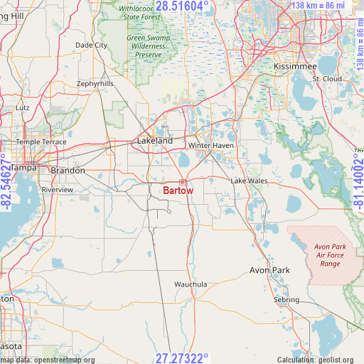
Bartow GPS coordinates[2]
27° 53' 47.076" North, 81° 50' 35.304" West
| Map corner | latitude | longitude |
|---|---|---|
| Upper-left | 28.51604°, | -82.54627° |
| Center: | 27.89641°, | -81.84314° |
| Lower-right: | 27.27322°, | -81.14002° |
| Map W x H: | 138.2×138.2 km | = 85.9×85.9mi |
| max Lat: | 71.29058° ⇑96.8% North |
| Bartow: | 27.89641° |
| min Lat: | ⇓3.2% South 19.06759° |
| min Long | Bartow | max Long |
| -171.73463° | -81.84314° | -66.98998° |
| W 66.1%⇐ | ⇒33.9% E |
Elevation
Elevation of Bartow is 46 m = 151 ft, and this is 248.8 m = 816 ft below average elevation for this country.
| Max E: |
3189 m = 10463 ft | 80.1% |
| Avg. | 294.8 m = 967 ft | |
| Bartow | 46 m = 151 ft | |
Min E: |
-60 m = -197 ft | 19.9% |
See also: United States elevation on elevation.city.
Geographical zone
Bartow is located in North temperate zone (between Tropic of Cancer and the Arctic Circle). Distance of this Northern Tropic circle is 495.9 km =308.1 mi to South.| Distance of | km | miles | from Bartow |
|---|---|---|---|
| North Pole | 6905.3 | 4290.8 | to North |
| Arctic Circle | 4299.4 | 2671.5 | to North |
| Tropic Cancer | 495.9 | 308.1 | to South |
| Equator | 3101.8 | 1927.4 | to South |


Nearby cities:
15 places around Bartow: (largest is in red/bold)
• Alturas
12.9 km =8 mi,  102°
102°
• Bradley Junction
17.6 km =10.9 mi,  230°
230°
• Crystal Lake
16.7 km =10.4 mi,  337°
337°
• Eagle Lake
12.5 km =7.8 mi,  43°
43°
• Fort Meade
16.5 km =10.3 mi,  165°
165°
• Fuller Heights
15.3 km =9.5 mi,  275°
275°
• Fussels Corner
17.6 km =10.9 mi,  354°
354°
• Highland City
8.4 km =5.2 mi, 335°
• Inwood
17.4 km =10.8 mi,  26°
26°
• Jan-Phyl Village
14.9 km =9.3 mi, 28°
• Lakeland Highlands
12.6 km =7.8 mi,  303°
303°
• Medulla
15.1 km =9.4 mi, 301°
• Mulberry
12.8 km =8 mi,  269°
269°
• Wahneta
13 km =8.1 mi,  61°
61°
• Willow Oak
17.3 km =10.7 mi, 277°
Sources, notices
• [Note1] Compared only with cities in United States existing in our database
• [Src1] Map data: © OpenStreetMap contributors (CC-BY-SA)
• [Src2] Other city data from geonames.org with taken over terms of usage.
• [Src3] Geographical zone / Annual Mean Temperature by Robert A. Rohde @ Wikipedia
