Jan-Phyl Village geodata
Jan-Phyl Village (Florida) is a populated place; located in United States in America/New_York (GMT-4) time zone. With population of 5,573 people, there are 6703 cities with bigger population in this country. Compared to other cities in United States, 96.6% of cities are located further ↑North; 66.4% of cities are located further ←West and 79.5% of cities have higher elevation than Jan-Phyl Village. Note1


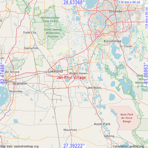
Jan-Phyl Village GPS coordinates[2]
28° 0' 53.064" North, 81° 46' 18.3" West
| Map corner | latitude | longitude |
|---|---|---|
| Upper-left | 28.63368°, | -82.47488° |
| Center: | 28.01474°, | -81.77175° |
| Lower-right: | 27.39222°, | -81.06863° |
| Map W x H: | 138×138 km | = 85.7×85.7mi |
| max Lat: | 71.29058° ⇑96.6% North |
| Jan-Phyl Village: | 28.01474° |
| min Lat: | ⇓3.4% South 19.06759° |
| min Long | Jan-Phyl Villag | max Long |
| -171.73463° | -81.77175° | -66.98998° |
| W 66.4%⇐ | ⇒33.6% E |
Elevation
Elevation of Jan-Phyl Village is 49 m = 161 ft, and this is 245.8 m = 806 ft below average elevation for this country.
| Max E: |
3189 m = 10463 ft | 79.5% |
| Avg. | 294.8 m = 967 ft | |
| Jan-Phyl Village | 49 m = 161 ft | |
Min E: |
-60 m = -197 ft | 20.5% |
See also: United States elevation on elevation.city.
Geographical zone
Jan-Phyl Village is located in North temperate zone (between Tropic of Cancer and the Arctic Circle). Distance of this Northern Tropic circle is 509 km =316.3 mi to South.| Distance of | km | miles | from Jan-Phyl Village |
|---|---|---|---|
| North Pole | 6892.1 | 4282.6 | to North |
| Arctic Circle | 4286.2 | 2663.3 | to North |
| Tropic Cancer | 509 | 316.3 | to South |
| Equator | 3114.9 | 1935.5 | to South |


Nearby cities:
15 places around Jan-Phyl Village: (largest is in red/bold)
• Auburndale
5.9 km =3.7 mi,  343°
343°
• Bartow
14.9 km =9.3 mi,  208°
208°
• Combee Settlement
14 km =8.7 mi,  290°
290°
• Crystal Lake
13.6 km =8.5 mi,  279°
279°
• Cypress Gardens
8.3 km =5.2 mi,  106°
106°
• Dundee
15 km =9.3 mi,  86°
86°
• Eagle Lake
4.3 km =2.7 mi,  159°
159°
• Fussels Corner
9.8 km =6.1 mi,  296°
296°
• Highland City
11.8 km =7.3 mi,  242°
242°
• Inwood
2.6 km =1.6 mi,  14°
14°
• Lake Alfred
9.8 km =6.1 mi,  28°
28°
• Lake Hamilton
14.5 km =9 mi,  76°
76°
• Wahneta
8.2 km =5.1 mi,  147°
147°
• Waverly
16 km =9.9 mi,  104°
104°
• Winter Haven
3.9 km =2.4 mi, 77°
Sources, notices
• [Note1] Compared only with cities in United States existing in our database
• [Src1] Map data: © OpenStreetMap contributors (CC-BY-SA)
• [Src2] Other city data from geonames.org with taken over terms of usage.
• [Src3] Geographical zone / Annual Mean Temperature by Robert A. Rohde @ Wikipedia
