Fort Meade geodata
Fort Meade (Florida) is a populated place; located in United States in America/New_York (GMT-4) time zone. With population of 5,975 people, there are 6423 cities with bigger population in this country. Compared to other cities in United States, 97.1% of cities are located further ↑North; 66.3% of cities are located further ←West and 79.9% of cities have higher elevation than Fort Meade. Note1


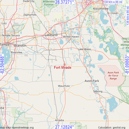
Fort Meade GPS coordinates[2]
27° 45' 8.1" North, 81° 48' 6.3" West
| Map corner | latitude | longitude |
|---|---|---|
| Upper-left | 28.37271°, | -82.50488° |
| Center: | 27.75225°, | -81.80175° |
| Lower-right: | 27.12824°, | -81.09863° |
| Map W x H: | 138.4×138.4 km | = 86×86mi |
| max Lat: | 71.29058° ⇑97.1% North |
| Fort Meade: | 27.75225° |
| min Lat: | ⇓2.9% South 19.06759° |
| min Long | Fort Meade | max Long |
| -171.73463° | -81.80175° | -66.98998° |
| W 66.3%⇐ | ⇒33.7% E |
Elevation
Elevation of Fort Meade is 47 m = 154 ft, and this is 247.8 m = 813 ft below average elevation for this country.
| Max E: |
3189 m = 10463 ft | 79.9% |
| Avg. | 294.8 m = 967 ft | |
| Fort Meade | 47 m = 154 ft | |
Min E: |
-60 m = -197 ft | 20.1% |
See also: United States elevation on elevation.city.
Geographical zone
Fort Meade is located in North temperate zone (between Tropic of Cancer and the Arctic Circle). Distance of this Northern Tropic circle is 479.8 km =298.1 mi to South.| Distance of | km | miles | from Fort Meade |
|---|---|---|---|
| North Pole | 6921.3 | 4300.7 | to North |
| Arctic Circle | 4315.4 | 2681.5 | to North |
| Tropic Cancer | 479.8 | 298.1 | to South |
| Equator | 3085.8 | 1917.4 | to South |


Nearby cities:
15 places around Fort Meade: (largest is in red/bold)
• Alturas
15.8 km =9.8 mi,  32°
32°
• Bartow
16.5 km =10.3 mi,  345°
345°
• Bowling Green
12.8 km =8 mi,  189°
189°
• Bradley Junction
18.2 km =11.3 mi,  285°
285°
• Crooked Lake Park
23.1 km =14.4 mi,  68°
68°
• Eagle Lake
25.5 km =15.8 mi,  10°
10°
• Frostproof
26.7 km =16.6 mi,  91°
91°
• Fuller Heights
26 km =16.2 mi,  312°
312°
• Highland City
24.8 km =15.4 mi,  342°
342°
• Lake Wales
26.9 km =16.7 mi,  51°
51°
• Lakeland Highlands
27.3 km =17 mi,  327°
327°
• Lemon Grove
24.8 km =15.4 mi,  150°
150°
• Mulberry
23.2 km =14.4 mi, 313°
• Wahneta
23.5 km =14.6 mi,  18°
18°
• Wauchula
22.8 km =14.2 mi,  182°
182°
Sources, notices
• [Note1] Compared only with cities in United States existing in our database
• [Src1] Map data: © OpenStreetMap contributors (CC-BY-SA)
• [Src2] Other city data from geonames.org with taken over terms of usage.
• [Src3] Geographical zone / Annual Mean Temperature by Robert A. Rohde @ Wikipedia
