Key Largo geodata
Key Largo (Florida) is a populated place; located in United States in America/New_York (GMT-4) time zone. With population of 10,433 people, there are 4339 cities with bigger population in this country. Compared to other cities in United States, 99.3% of cities are located further ↑North; 71% of cities are located further ←West and 95.7% of cities have higher elevation than Key Largo. Note1


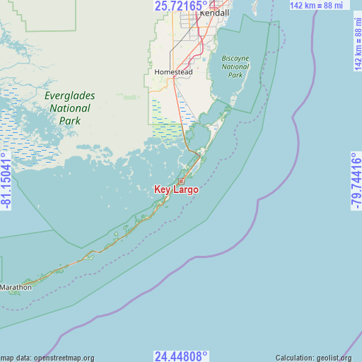
Key Largo GPS coordinates[2]
25° 5' 11.472" North, 80° 26' 50.208" West
| Map corner | latitude | longitude |
|---|---|---|
| Upper-left | 25.72165°, | -81.15041° |
| Center: | 25.08652°, | -80.44728° |
| Lower-right: | 24.44808°, | -79.74416° |
| Map W x H: | 141.6×141.6 km | = 88×88mi |
| max Lat: | 71.29058° ⇑99.3% North |
| Key Largo: | 25.08652° |
| min Lat: | ⇓0.7% South 19.06759° |
| min Long | Key Largo | max Long |
| -171.73463° | -80.44728° | -66.98998° |
| W 71%⇐ | ⇒29% E |
Elevation
Elevation of Key Largo is 8 m = 26 ft, and this is 286.8 m = 941 ft below average elevation for this country.
| Max E: |
3189 m = 10463 ft | 95.7% |
| Avg. | 294.8 m = 967 ft | |
| Key Largo | 8 m = 26 ft | |
Min E: |
-60 m = -197 ft | 4.3% |
See also: United States elevation on elevation.city.
Geographical zone
Key Largo is located in North temperate zone (between Tropic of Cancer and the Arctic Circle). Distance of this Northern Tropic circle is 183.4 km =114 mi to South.| Distance of | km | miles | from Key Largo |
|---|---|---|---|
| North Pole | 7217.7 | 4484.9 | to North |
| Arctic Circle | 4611.8 | 2865.6 | to North |
| Tropic Cancer | 183.4 | 114 | to South |
| Equator | 2789.4 | 1733.3 | to South |


Nearby cities:
15 places around Key Largo: (largest is in red/bold)
• Cutler Bay
55.8 km =34.7 mi,  11°
11°
• Cutler Ridge
55.9 km =34.7 mi, 10°
• Florida City
40.3 km =25 mi,  355°
355°
• Goulds
53.3 km =33.1 mi, 7°
• Homestead
42.6 km =26.5 mi, 355°
• Homestead Base
45.6 km =28.3 mi, 7°
• Islamorada
25.6 km =15.9 mi,  225°
225°
• Lakes by the Bay
55.4 km =34.4 mi, 12°
• Leisure City
45.5 km =28.3 mi,  2°
2°
• Naranja
48.1 km =29.9 mi, 2°
• North Key Largo
23.7 km =14.7 mi,  31°
31°
• Plantation
16.2 km =10.1 mi,  220°
220°
• Princeton
50.4 km =31.3 mi, 4°
• South Miami Heights
57.2 km =35.5 mi, 6°
• Tavernier
10.8 km =6.7 mi, 219°
Sources, notices
• [Note1] Compared only with cities in United States existing in our database
• [Src1] Map data: © OpenStreetMap contributors (CC-BY-SA)
• [Src2] Other city data from geonames.org with taken over terms of usage.
• [Src3] Geographical zone / Annual Mean Temperature by Robert A. Rohde @ Wikipedia
