Key West geodata
Key West (Florida) is a seat of a second-order administrative division; located in United States in America/New_York (GMT-4) time zone. With population of 25,755 people, there are 1945 cities with bigger population in this country. Compared to other cities in United States, 99.4% of cities are located further ↑North; 66.4% of cities are located further ←West and 99.4% of cities have higher elevation than Key West. Note1


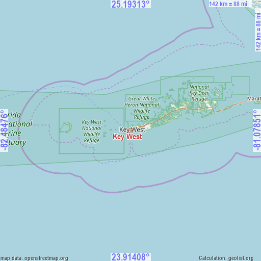
Key West GPS coordinates[2]
24° 33' 18.864" North, 81° 46' 53.868" West
| Map corner | latitude | longitude |
|---|---|---|
| Upper-left | 25.19313°, | -82.48476° |
| Center: | 24.55524°, | -81.78163° |
| Lower-right: | 23.91408°, | -81.07851° |
| Map W x H: | 142.2×142.2 km | = 88.4×88.4mi |
| max Lat: | 71.29058° ⇑99.4% North |
| Key West: | 24.55524° |
| min Lat: | ⇓0.6% South 19.06759° |
| min Long | Key West | max Long |
| -171.73463° | -81.78163° | -66.98998° |
| W 66.4%⇐ | ⇒33.6% E |
Elevation
Elevation of Key West is 2 m = 7 ft, and this is 292.8 m = 961 ft below average elevation for this country.
| Max E: |
3189 m = 10463 ft | 99.4% |
| Avg. | 294.8 m = 967 ft | |
| Key West | 2 m = 7 ft | |
Min E: |
-60 m = -197 ft | 0.6% |
See also: United States elevation on elevation.city.
Geographical zone
Key West is located in North temperate zone (between Tropic of Cancer and the Arctic Circle). Distance of this Northern Tropic circle is 124.4 km =77.3 mi to South.| Distance of | km | miles | from Key West |
|---|---|---|---|
| North Pole | 7276.8 | 4521.6 | to North |
| Arctic Circle | 4670.9 | 2902.4 | to North |
| Tropic Cancer | 124.4 | 77.3 | to South |
| Equator | 2730.3 | 1696.5 | to South |


Nearby cities:
15 places around Key West: (largest is in red/bold)
• Big Coppitt Key
13.1 km =8.1 mi,  69°
69°
• Big Pine Key
45.1 km =28 mi, 73°
• Cudjoe Key
31.4 km =19.5 mi, 65°
• Duck Key
91.1 km =56.6 mi, 74°
• Florida City
164.5 km =102.2 mi,  52°
52°
• Homestead
166.1 km =103.2 mi, 52°
• Islamorada
123.5 km =76.7 mi, 70°
• Key Colony Beach
79.3 km =49.3 mi,  76°
76°
• Key Largo
147 km =91.3 mi, 66°
• Marathon
72.1 km =44.8 mi, 75°
• Marco
157.7 km =98 mi,  1°
1°
• Marco Island
154.2 km =95.8 mi, 2°
• Plantation
132.7 km =82.5 mi, 69°
• Stock Island
4.6 km =2.9 mi, 73°
• Tavernier
137.6 km =85.5 mi, 68°
Sources, notices
• [Note1] Compared only with cities in United States existing in our database
• [Src1] Map data: © OpenStreetMap contributors (CC-BY-SA)
• [Src2] Other city data from geonames.org with taken over terms of usage.
• [Src3] Geographical zone / Annual Mean Temperature by Robert A. Rohde @ Wikipedia
