Lake Mary geodata
Lake Mary (Florida) is a populated place; located in United States in America/New_York (GMT-4) time zone. With population of 16,021 people, there are 3057 cities with bigger population in this country. Compared to other cities in United States, 95.6% of cities are located further ↑North; 68.5% of cities are located further ←West and 87% of cities have higher elevation than Lake Mary. Note1


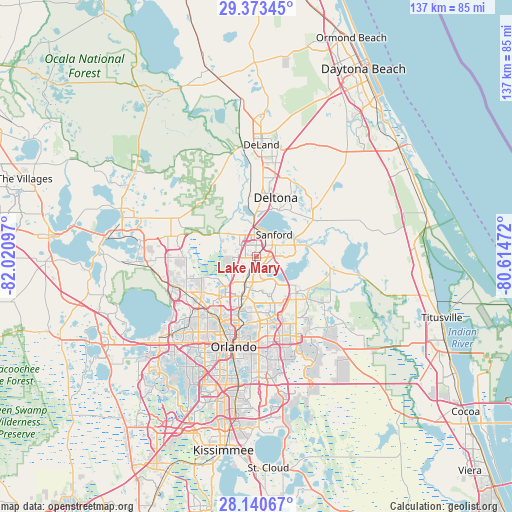
Lake Mary GPS coordinates[2]
28° 45' 31.968" North, 81° 19' 4.224" West
| Map corner | latitude | longitude |
|---|---|---|
| Upper-left | 29.37345°, | -82.02097° |
| Center: | 28.75888°, | -81.31784° |
| Lower-right: | 28.14067°, | -80.61472° |
| Map W x H: | 137.1×137.1 km | = 85.2×85.2mi |
| max Lat: | 71.29058° ⇑95.6% North |
| Lake Mary: | 28.75888° |
| min Lat: | ⇓4.4% South 19.06759° |
| min Long | Lake Mary | max Long |
| -171.73463° | -81.31784° | -66.98998° |
| W 68.5%⇐ | ⇒31.5% E |
Elevation
Elevation of Lake Mary is 23 m = 75 ft, and this is 271.8 m = 892 ft below average elevation for this country.
| Max E: |
3189 m = 10463 ft | 87% |
| Avg. | 294.8 m = 967 ft | |
| Lake Mary | 23 m = 75 ft | |
Min E: |
-60 m = -197 ft | 13% |
See also: United States elevation on elevation.city.
Geographical zone
Lake Mary is located in North temperate zone (between Tropic of Cancer and the Arctic Circle). Distance of this Northern Tropic circle is 591.8 km =367.7 mi to South.| Distance of | km | miles | from Lake Mary |
|---|---|---|---|
| North Pole | 6809.4 | 4231.2 | to North |
| Arctic Circle | 4203.5 | 2611.9 | to North |
| Tropic Cancer | 591.8 | 367.7 | to South |
| Equator | 3197.7 | 1987 | to South |


Nearby cities:
15 places around Lake Mary: (largest is in red/bold)
• Altamonte Springs
11.8 km =7.3 mi,  203°
203°
• Casselberry
9.1 km =5.7 mi,  186°
186°
• DeBary
13.8 km =8.6 mi,  3°
3°
• Deltona
16.6 km =10.3 mi,  18°
18°
• Fern Park
12.6 km =7.8 mi, 194°
• Forest City
16 km =9.9 mi,  230°
230°
• Goldenrod
16.8 km =10.4 mi,  170°
170°
• Heathrow
5.3 km =3.3 mi,  275°
275°
• Longwood
6.5 km =4 mi, 197°
• Maitland
15.2 km =9.4 mi, 196°
• Midway
9.2 km =5.7 mi,  67°
67°
• Oviedo
14.6 km =9.1 mi,  132°
132°
• Sanford
6.4 km =4 mi,  43°
43°
• Wekiwa Springs
12.5 km =7.8 mi,  237°
237°
• Winter Springs
6.7 km =4.2 mi, 171°
Sources, notices
• [Note1] Compared only with cities in United States existing in our database
• [Src1] Map data: © OpenStreetMap contributors (CC-BY-SA)
• [Src2] Other city data from geonames.org with taken over terms of usage.
• [Src3] Geographical zone / Annual Mean Temperature by Robert A. Rohde @ Wikipedia
