Deltona geodata
Deltona (Florida) is a populated place; located in United States in America/New_York (GMT-4) time zone. With population of 88,474 people, there are 419 cities with bigger population in this country. Compared to other cities in United States, 95.4% of cities are located further ↑North; 68.7% of cities are located further ←West and 91.5% of cities have higher elevation than Deltona. Note1


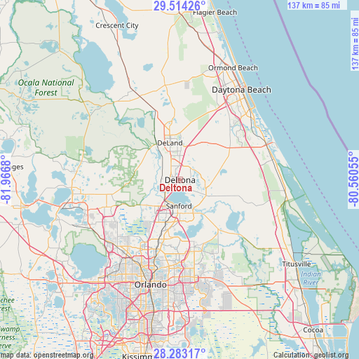
Deltona GPS coordinates[2]
28° 54' 1.944" North, 81° 15' 49.212" West
| Map corner | latitude | longitude |
|---|---|---|
| Upper-left | 29.51426°, | -81.9668° |
| Center: | 28.90054°, | -81.26367° |
| Lower-right: | 28.28317°, | -80.56055° |
| Map W x H: | 136.9×136.9 km | = 85.1×85.1mi |
| max Lat: | 71.29058° ⇑95.4% North |
| Deltona: | 28.90054° |
| min Lat: | ⇓4.6% South 19.06759° |
| min Long | Deltona | max Long |
| -171.73463° | -81.26367° | -66.98998° |
| W 68.7%⇐ | ⇒31.3% E |
Elevation
Elevation of Deltona is 13 m = 43 ft, and this is 281.8 m = 925 ft below average elevation for this country.
| Max E: |
3189 m = 10463 ft | 91.5% |
| Avg. | 294.8 m = 967 ft | |
| Deltona | 13 m = 43 ft | |
Min E: |
-60 m = -197 ft | 8.5% |
See also: Deltona elevation on elevation.city.
Geographical zone
Deltona is located in North temperate zone (between Tropic of Cancer and the Arctic Circle). Distance of this Northern Tropic circle is 607.5 km =377.5 mi to South.| Distance of | km | miles | from Deltona |
|---|---|---|---|
| North Pole | 6793.6 | 4221.3 | to North |
| Arctic Circle | 4187.7 | 2602.1 | to North |
| Tropic Cancer | 607.5 | 377.5 | to South |
| Equator | 3213.4 | 1996.7 | to South |


Nearby cities:
15 places around Deltona: (largest is in red/bold)
• De Land Southwest
12.8 km =8 mi,  338°
338°
• DeBary
4.8 km =3 mi,  246°
246°
• DeLand
14.7 km =9.1 mi, 344°
• Geneva
23 km =14.3 mi,  141°
141°
• Heathrow
18.6 km =11.6 mi,  214°
214°
• Lake Helen
9.4 km =5.8 mi,  18°
18°
• Lake Mack-Forest Hills
19.2 km =11.9 mi,  305°
305°
• Lake Mary
16.6 km =10.3 mi,  198°
198°
• Midway
12.7 km =7.9 mi,  165°
165°
• North DeLand
16.9 km =10.5 mi,  348°
348°
• Orange City
6.4 km =4 mi,  327°
327°
• Pine Lakes
16.8 km =10.4 mi,  285°
285°
• Sanford
11.2 km =7 mi,  184°
184°
• West DeLand
14.5 km =9 mi, 332°
• Winter Springs
22.8 km =14.2 mi,  190°
190°
Sources, notices
• [Note1] Compared only with cities in United States existing in our database
• [Src1] Map data: © OpenStreetMap contributors (CC-BY-SA)
• [Src2] Other city data from geonames.org with taken over terms of usage.
• [Src3] Geographical zone / Annual Mean Temperature by Robert A. Rohde @ Wikipedia
