Sanford geodata
Sanford (Florida) is a seat of a second-order administrative division; located in United States in America/New_York (GMT-4) time zone. With population of 58,111 people, there are 784 cities with bigger population in this country. Compared to other cities in United States, 95.5% of cities are located further ↑North; 68.6% of cities are located further ←West and 95.7% of cities have higher elevation than Sanford. Note1


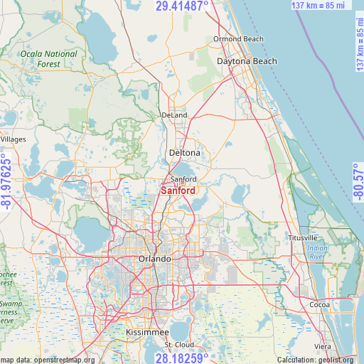
Sanford GPS coordinates[2]
28° 48' 1.98" North, 81° 16' 23.232" West
| Map corner | latitude | longitude |
|---|---|---|
| Upper-left | 29.41487°, | -81.97625° |
| Center: | 28.80055°, | -81.27312° |
| Lower-right: | 28.18259°, | -80.57° |
| Map W x H: | 137×137 km | = 85.1×85.1mi |
| max Lat: | 71.29058° ⇑95.5% North |
| Sanford: | 28.80055° |
| min Lat: | ⇓4.5% South 19.06759° |
| min Long | Sanford | max Long |
| -171.73463° | -81.27312° | -66.98998° |
| W 68.6%⇐ | ⇒31.4% E |
Elevation
Elevation of Sanford is 8 m = 26 ft, and this is 286.8 m = 941 ft below average elevation for this country.
| Max E: |
3189 m = 10463 ft | 95.7% |
| Avg. | 294.8 m = 967 ft | |
| Sanford | 8 m = 26 ft | |
Min E: |
-60 m = -197 ft | 4.3% |
See also: Sanford elevation on elevation.city.
Geographical zone
Sanford is located in North temperate zone (between Tropic of Cancer and the Arctic Circle). Distance of this Northern Tropic circle is 596.4 km =370.6 mi to South.| Distance of | km | miles | from Sanford |
|---|---|---|---|
| North Pole | 6804.7 | 4228.2 | to North |
| Arctic Circle | 4198.9 | 2609.1 | to North |
| Tropic Cancer | 596.4 | 370.6 | to South |
| Equator | 3202.3 | 1989.8 | to South |


Nearby cities:
15 places around Sanford: (largest is in red/bold)
• Altamonte Springs
17.9 km =11.1 mi,  210°
210°
• Casselberry
14.7 km =9.1 mi,  201°
201°
• DeBary
9.8 km =6.1 mi,  339°
339°
• Deltona
11.2 km =7 mi,  4°
4°
• Fern Park
18.5 km =11.5 mi, 204°
• Geneva
16.8 km =10.4 mi,  113°
113°
• Heathrow
10.5 km =6.5 mi,  246°
246°
• Lake Helen
20.4 km =12.7 mi,  10°
10°
• Lake Mary
6.4 km =4 mi,  223°
223°
• Longwood
12.6 km =7.8 mi, 210°
• Midway
4.3 km =2.7 mi, 105°
• Orange City
16.7 km =10.4 mi,  351°
351°
• Oviedo
15.8 km =9.8 mi,  156°
156°
• Wekiwa Springs
18.7 km =11.6 mi,  232°
232°
• Winter Springs
11.8 km =7.3 mi, 196°
Sources, notices
• [Note1] Compared only with cities in United States existing in our database
• [Src1] Map data: © OpenStreetMap contributors (CC-BY-SA)
• [Src2] Other city data from geonames.org with taken over terms of usage.
• [Src3] Geographical zone / Annual Mean Temperature by Robert A. Rohde @ Wikipedia
