Ocala geodata
Ocala (Florida) is a seat of a second-order administrative division; located in United States in America/New_York (GMT-4) time zone. With population of 58,218 people, there are 781 cities with bigger population in this country. Compared to other cities in United States, 95.1% of cities are located further ↑North; 65.1% of cities are located further ←West and 86.6% of cities have higher elevation than Ocala. Note1


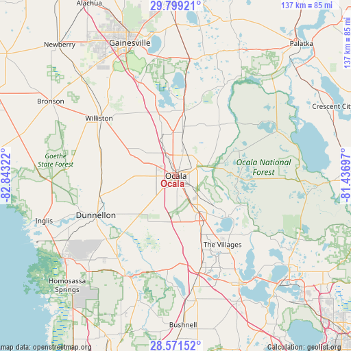
Ocala GPS coordinates[2]
29° 11' 13.92" North, 82° 8' 24.324" West
| Map corner | latitude | longitude |
|---|---|---|
| Upper-left | 29.79921°, | -82.84322° |
| Center: | 29.1872°, | -82.14009° |
| Lower-right: | 28.57152°, | -81.43697° |
| Map W x H: | 136.5×136.5 km | = 84.8×84.8mi |
| max Lat: | 71.29058° ⇑95.1% North |
| Ocala: | 29.1872° |
| min Lat: | ⇓4.9% South 19.06759° |
| min Long | Ocala | max Long |
| -171.73463° | -82.14009° | -66.98998° |
| W 65.1%⇐ | ⇒34.9% E |
Elevation
Elevation of Ocala is 24 m = 79 ft, and this is 270.8 m = 888 ft below average elevation for this country.
| Max E: |
3189 m = 10463 ft | 86.6% |
| Avg. | 294.8 m = 967 ft | |
| Ocala | 24 m = 79 ft | |
Min E: |
-60 m = -197 ft | 13.4% |
See also: Ocala elevation on elevation.city.
Geographical zone
Ocala is located in North temperate zone (between Tropic of Cancer and the Arctic Circle). Distance of this Northern Tropic circle is 639.4 km =397.3 mi to South.| Distance of | km | miles | from Ocala |
|---|---|---|---|
| North Pole | 6761.7 | 4201.5 | to North |
| Arctic Circle | 4155.9 | 2582.4 | to North |
| Tropic Cancer | 639.4 | 397.3 | to South |
| Equator | 3245.3 | 2016.5 | to South |


Nearby cities:
15 places around Ocala: (largest is in red/bold)
• Belleview
16.5 km =10.3 mi,  152°
152°
• Citra
25.2 km =15.7 mi,  6°
6°
• Citrus Springs
38.4 km =23.9 mi,  236°
236°
• Dunnellon
34.7 km =21.6 mi, 243°
• East Williston
35 km =21.7 mi,  309°
309°
• Hernando
39.2 km =24.4 mi,  215°
215°
• Lady Lake
36.7 km =22.8 mi,  144°
144°
• Micanopy
37.8 km =23.5 mi,  339°
339°
• Reddick
20.7 km =12.9 mi, 344°
• Silver Springs
8.7 km =5.4 mi,  67°
67°
• Silver Springs Shores
14.8 km =9.2 mi,  128°
128°
• The Villages
33.1 km =20.6 mi, 148°
• Wildwood
37.1 km =23.1 mi,  164°
164°
• Williston
37.2 km =23.1 mi, 306°
• Williston Highlands
42.5 km =26.4 mi,  293°
293°
Sources, notices
• [Note1] Compared only with cities in United States existing in our database
• [Src1] Map data: © OpenStreetMap contributors (CC-BY-SA)
• [Src2] Other city data from geonames.org with taken over terms of usage.
• [Src3] Geographical zone / Annual Mean Temperature by Robert A. Rohde @ Wikipedia
