Silver Springs Shores geodata
Silver Springs Shores (Florida) is a populated place; located in United States in America/New_York (GMT-4) time zone. With population of 6,539 people, there are 6085 cities with bigger population in this country. Compared to other cities in United States, 95.1% of cities are located further ↑North; 65.5% of cities are located further ←West and 83.6% of cities have higher elevation than Silver Springs Shores. Note1
Current local time in Silver Springs Shores:
01:49 AM, WednesdayDifference from your time zone: hours


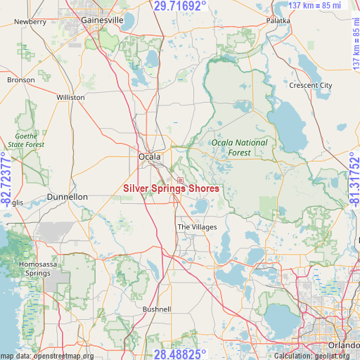
Silver Springs Shores GPS coordinates[2]
29° 6' 15.912" North, 82° 1' 14.304" West
| Map corner | latitude | longitude |
|---|---|---|
| Upper-left | 29.71692°, | -82.72377° |
| Center: | 29.10442°, | -82.02064° |
| Lower-right: | 28.48825°, | -81.31752° |
| Map W x H: | 136.6×136.6 km | = 84.9×84.9mi |
| max Lat: | 71.29058° ⇑95.1% North |
| Silver Springs Shores: | 29.10442° |
| min Lat: | ⇓4.9% South 19.06759° |
| min Long | Silver Springs | max Long |
| -171.73463° | -82.02064° | -66.98998° |
| W 65.5%⇐ | ⇒34.5% E |
Elevation
Elevation of Silver Springs Shores is 33 m = 108 ft, and this is 261.8 m = 859 ft below average elevation for this country.
| Max E: |
3189 m = 10463 ft | 83.6% |
| Avg. | 294.8 m = 967 ft | |
| Silver Springs Shores | 33 m = 108 ft | |
Min E: |
-60 m = -197 ft | 16.4% |
See also: United States elevation on elevation.city.
Geographical zone
Silver Springs Shores is located in North temperate zone (between Tropic of Cancer and the Arctic Circle). Distance of this Northern Tropic circle is 630.2 km =391.6 mi to South.| Distance of | km | miles | from Silver Springs Shores |
|---|---|---|---|
| North Pole | 6771 | 4207.3 | to North |
| Arctic Circle | 4165.1 | 2588.1 | to North |
| Tropic Cancer | 630.2 | 391.6 | to South |
| Equator | 3236.1 | 2010.8 | to South |


Nearby cities:
15 places around Silver Springs Shores: (largest is in red/bold)
• Belleview
6.8 km =4.2 mi,  216°
216°
• Citra
35.3 km =21.9 mi,  345°
345°
• Coleman
34.2 km =21.3 mi,  188°
188°
• Fruitland Park
29.2 km =18.1 mi,  157°
157°
• Hawthorne
40.8 km =25.4 mi, 159°
• Lady Lake
22.9 km =14.2 mi, 155°
• Lake Panasoffkee
39.4 km =24.5 mi, 190°
• Leesburg
35.5 km =22.1 mi, 156°
• Ocala
14.8 km =9.2 mi,  308°
308°
• Reddick
33.8 km =21 mi,  329°
329°
• Silver Lake
36.3 km =22.6 mi,  143°
143°
• Silver Springs
13 km =8.1 mi,  343°
343°
• The Villages
19.8 km =12.3 mi, 162°
• Umatilla
39.6 km =24.6 mi,  119°
119°
• Wildwood
26.6 km =16.5 mi,  184°
184°
Sources, notices
• [Note1] Compared only with cities in United States existing in our database
• [Src1] Map data: © OpenStreetMap contributors (CC-BY-SA)
• [Src2] Other city data from geonames.org with taken over terms of usage.
• [Src3] Geographical zone / Annual Mean Temperature by Robert A. Rohde @ Wikipedia
