Penney Farms geodata
Penney Farms (Florida) is a populated place; located in United States in America/New_York (GMT-4) time zone. With population of 815 people, there are 17673 cities with bigger population in this country. Compared to other cities in United States, 93.5% of cities are located further ↑North; 66.2% of cities are located further ←West and 83.2% of cities have higher elevation than Penney Farms. Note1


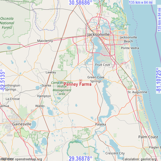
Penney Farms GPS coordinates[2]
29° 58' 46.884" North, 81° 48' 37.332" West
| Map corner | latitude | longitude |
|---|---|---|
| Upper-left | 30.58686°, | -82.5135° |
| Center: | 29.97969°, | -81.81037° |
| Lower-right: | 29.36878°, | -81.10725° |
| Map W x H: | 135.4×135.4 km | = 84.1×84.1mi |
| max Lat: | 71.29058° ⇑93.5% North |
| Penney Farms: | 29.97969° |
| min Lat: | ⇓6.5% South 19.06759° |
| min Long | Penney Farms | max Long |
| -171.73463° | -81.81037° | -66.98998° |
| W 66.2%⇐ | ⇒33.8% E |
Elevation
Elevation of Penney Farms is 34 m = 112 ft, and this is 260.8 m = 856 ft below average elevation for this country.
| Max E: |
3189 m = 10463 ft | 83.2% |
| Avg. | 294.8 m = 967 ft | |
| Penney Farms | 34 m = 112 ft | |
Min E: |
-60 m = -197 ft | 16.8% |
See also: United States elevation on elevation.city.
Geographical zone
Penney Farms is located in North temperate zone (between Tropic of Cancer and the Arctic Circle). Distance of this Northern Tropic circle is 727.5 km =452 mi to South.| Distance of | km | miles | from Penney Farms |
|---|---|---|---|
| North Pole | 6673.6 | 4146.8 | to North |
| Arctic Circle | 4067.7 | 2527.6 | to North |
| Tropic Cancer | 727.5 | 452 | to South |
| Equator | 3333.4 | 2071.3 | to South |


Nearby cities:
15 places around Penney Farms: (largest is in red/bold)
• Asbury Lake
7.8 km =4.8 mi,  352°
352°
• Baldwin
39.3 km =24.4 mi,  336°
336°
• Bellair-Meadowbrook Terrace
23.1 km =14.4 mi,  16°
16°
• Fleming Island
15.4 km =9.6 mi,  34°
34°
• Fruit Cove
21.8 km =13.5 mi,  48°
48°
• Green Cove Springs
12.8 km =8 mi,  83°
83°
• Interlachen
40.3 km =25 mi,  191°
191°
• Keystone Heights
30.3 km =18.8 mi,  224°
224°
• Lakeside
17.2 km =10.7 mi,  13°
13°
• Lawtey
26.2 km =16.3 mi,  285°
285°
• Middleburg
11 km =6.8 mi,  334°
334°
• Oakleaf Plantation
21.4 km =13.3 mi, 353°
• Orange Park
23 km =14.3 mi, 25°
• St. Johns
27.7 km =17.2 mi,  65°
65°
• Starke
29.1 km =18.1 mi,  262°
262°
Sources, notices
• [Note1] Compared only with cities in United States existing in our database
• [Src1] Map data: © OpenStreetMap contributors (CC-BY-SA)
• [Src2] Other city data from geonames.org with taken over terms of usage.
• [Src3] Geographical zone / Annual Mean Temperature by Robert A. Rohde @ Wikipedia
