Keystone Heights geodata
Keystone Heights (Florida) is a populated place; located in United States in America/New_York (GMT-4) time zone. With population of 1,433 people, there are 13951 cities with bigger population in this country. Compared to other cities in United States, 93.9% of cities are located further ↑North; 65.4% of cities are located further ←West and 80.3% of cities have higher elevation than Keystone Heights. Note1


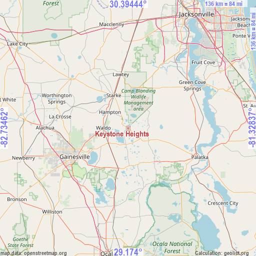
Keystone Heights GPS coordinates[2]
29° 47' 9.888" North, 82° 1' 53.364" West
| Map corner | latitude | longitude |
|---|---|---|
| Upper-left | 30.39444°, | -82.73462° |
| Center: | 29.78608°, | -82.03149° |
| Lower-right: | 29.174°, | -81.32837° |
| Map W x H: | 135.7×135.7 km | = 84.3×84.3mi |
| max Lat: | 71.29058° ⇑93.9% North |
| Keystone Heights: | 29.78608° |
| min Lat: | ⇓6.1% South 19.06759° |
| min Long | Keystone Height | max Long |
| -171.73463° | -82.03149° | -66.98998° |
| W 65.4%⇐ | ⇒34.6% E |
Elevation
Elevation of Keystone Heights is 45 m = 148 ft, and this is 249.8 m = 820 ft below average elevation for this country.
| Max E: |
3189 m = 10463 ft | 80.3% |
| Avg. | 294.8 m = 967 ft | |
| Keystone Heights | 45 m = 148 ft | |
Min E: |
-60 m = -197 ft | 19.7% |
See also: United States elevation on elevation.city.
Geographical zone
Keystone Heights is located in North temperate zone (between Tropic of Cancer and the Arctic Circle). Distance of this Northern Tropic circle is 706 km =438.7 mi to South.| Distance of | km | miles | from Keystone Heights |
|---|---|---|---|
| North Pole | 6695.2 | 4160.2 | to North |
| Arctic Circle | 4089.3 | 2541 | to North |
| Tropic Cancer | 706 | 438.7 | to South |
| Equator | 3311.9 | 2057.9 | to South |


Nearby cities:
15 places around Keystone Heights: (largest is in red/bold)
• Alachua
38.2 km =23.7 mi,  264°
264°
• Asbury Lake
35.6 km =22.1 mi,  34°
34°
• Citra
42.3 km =26.3 mi,  190°
190°
• Gainesville
32 km =19.9 mi,  242°
242°
• Green Cove Springs
41 km =25.5 mi,  56°
56°
• Hawthorne
22.3 km =13.9 mi, 194°
• Interlachen
22.4 km =13.9 mi,  143°
143°
• Lake Butler
39.7 km =24.7 mi,  311°
311°
• Lawtey
29 km =18 mi,  352°
352°
• Micanopy
39.4 km =24.5 mi,  217°
217°
• Middleburg
35.5 km =22.1 mi, 27°
• Palatka
41 km =25.5 mi,  111°
111°
• Penney Farms
30.3 km =18.8 mi,  44°
44°
• Starke
19.1 km =11.9 mi,  336°
336°
• Waldo
13.1 km =8.1 mi,  271°
271°
Sources, notices
• [Note1] Compared only with cities in United States existing in our database
• [Src1] Map data: © OpenStreetMap contributors (CC-BY-SA)
• [Src2] Other city data from geonames.org with taken over terms of usage.
• [Src3] Geographical zone / Annual Mean Temperature by Robert A. Rohde @ Wikipedia
