Pine Hills geodata
Pine Hills (Florida) is a populated place; located in United States in America/New_York (GMT-4) time zone. With population of 60,076 people, there are 743 cities with bigger population in this country. Compared to other cities in United States, 95.9% of cities are located further ↑North; 67.8% of cities are located further ←West and 81.3% of cities have higher elevation than Pine Hills. Note1


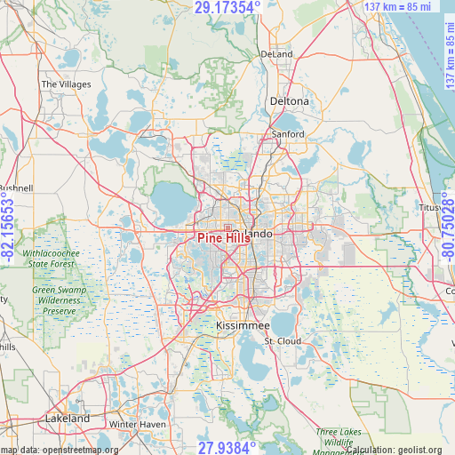
Pine Hills GPS coordinates[2]
28° 33' 28.008" North, 81° 27' 12.24" West
| Map corner | latitude | longitude |
|---|---|---|
| Upper-left | 29.17354°, | -82.15653° |
| Center: | 28.55778°, | -81.4534° |
| Lower-right: | 27.9384°, | -80.75028° |
| Map W x H: | 137.3×137.3 km | = 85.3×85.3mi |
| max Lat: | 71.29058° ⇑95.9% North |
| Pine Hills: | 28.55778° |
| min Lat: | ⇓4.1% South 19.06759° |
| min Long | Pine Hills | max Long |
| -171.73463° | -81.4534° | -66.98998° |
| W 67.8%⇐ | ⇒32.2% E |
Elevation
Elevation of Pine Hills is 41 m = 135 ft, and this is 253.8 m = 833 ft below average elevation for this country.
| Max E: |
3189 m = 10463 ft | 81.3% |
| Avg. | 294.8 m = 967 ft | |
| Pine Hills | 41 m = 135 ft | |
Min E: |
-60 m = -197 ft | 18.7% |
See also: Pine Hills elevation on elevation.city.
Geographical zone
Pine Hills is located in North temperate zone (between Tropic of Cancer and the Arctic Circle). Distance of this Northern Tropic circle is 569.4 km =353.8 mi to South.| Distance of | km | miles | from Pine Hills |
|---|---|---|---|
| North Pole | 6831.7 | 4245 | to North |
| Arctic Circle | 4225.8 | 2625.8 | to North |
| Tropic Cancer | 569.4 | 353.8 | to South |
| Equator | 3175.3 | 1973 | to South |


Nearby cities:
15 places around Pine Hills: (largest is in red/bold)
• Clarcona
7.5 km =4.7 mi,  324°
324°
• Eatonville
9.5 km =5.9 mi,  48°
48°
• Edgewood
11.2 km =7 mi,  135°
135°
• Fairview Shores
6.9 km =4.3 mi,  57°
57°
• Gotha
7.6 km =4.7 mi,  243°
243°
• Holden Heights
9.3 km =5.8 mi, 136°
• Lake Butler
10.6 km =6.6 mi,  233°
233°
• Lockhart
6.9 km =4.3 mi,  8°
8°
• Oak Ridge
10 km =6.2 mi,  163°
163°
• Ocoee
8.9 km =5.5 mi,  278°
278°
• Orlando
7.6 km =4.7 mi,  106°
106°
• Orlovista
2.3 km =1.4 mi,  197°
197°
• Paradise Heights
11.5 km =7.1 mi,  309°
309°
• Tangelo Park
11.4 km =7.1 mi,  176°
176°
• Windermere
10.5 km =6.5 mi, 228°
Sources, notices
• [Note1] Compared only with cities in United States existing in our database
• [Src1] Map data: © OpenStreetMap contributors (CC-BY-SA)
• [Src2] Other city data from geonames.org with taken over terms of usage.
• [Src3] Geographical zone / Annual Mean Temperature by Robert A. Rohde @ Wikipedia
