Paradise Heights geodata
Paradise Heights (Florida) is a populated place; located in United States in America/New_York (GMT-4) time zone. With population of 1,215 people, there are 15036 cities with bigger population in this country. Compared to other cities in United States, 95.7% of cities are located further ↑North; 67.3% of cities are located further ←West and 81.8% of cities have higher elevation than Paradise Heights. Note1


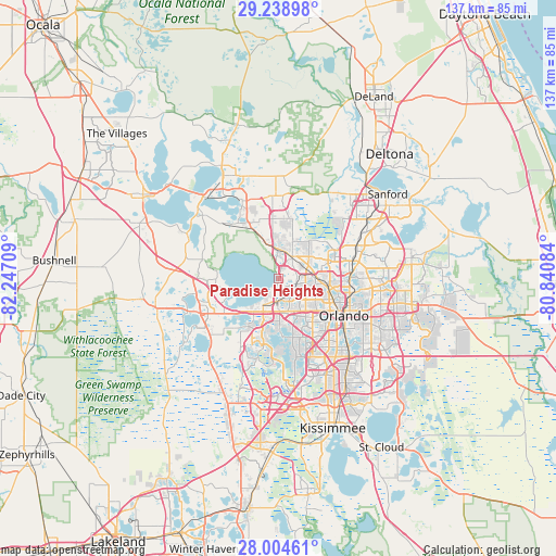
Paradise Heights GPS coordinates[2]
28° 37' 24.996" North, 81° 32' 38.256" West
| Map corner | latitude | longitude |
|---|---|---|
| Upper-left | 29.23898°, | -82.24709° |
| Center: | 28.62361°, | -81.54396° |
| Lower-right: | 28.00461°, | -80.84084° |
| Map W x H: | 137.2×137.3 km | = 85.3×85.3mi |
| max Lat: | 71.29058° ⇑95.7% North |
| Paradise Heights: | 28.62361° |
| min Lat: | ⇓4.3% South 19.06759° |
| min Long | Paradise Height | max Long |
| -171.73463° | -81.54396° | -66.98998° |
| W 67.3%⇐ | ⇒32.7% E |
Elevation
Elevation of Paradise Heights is 39 m = 128 ft, and this is 255.8 m = 839 ft below average elevation for this country.
| Max E: |
3189 m = 10463 ft | 81.8% |
| Avg. | 294.8 m = 967 ft | |
| Paradise Heights | 39 m = 128 ft | |
Min E: |
-60 m = -197 ft | 18.2% |
See also: United States elevation on elevation.city.
Geographical zone
Paradise Heights is located in North temperate zone (between Tropic of Cancer and the Arctic Circle). Distance of this Northern Tropic circle is 576.7 km =358.3 mi to South.| Distance of | km | miles | from Paradise Heights |
|---|---|---|---|
| North Pole | 6824.4 | 4240.5 | to North |
| Arctic Circle | 4218.5 | 2621.3 | to North |
| Tropic Cancer | 576.7 | 358.3 | to South |
| Equator | 3182.6 | 1977.6 | to South |


Nearby cities:
15 places around Paradise Heights: (largest is in red/bold)
• Apopka
6.6 km =4.1 mi,  28°
28°
• Clarcona
4.6 km =2.9 mi,  105°
105°
• Forest City
10.9 km =6.8 mi,  63°
63°
• Gotha
10.8 km =6.7 mi,  169°
169°
• Lake Butler
13.6 km =8.5 mi,  178°
178°
• Lockhart
9.9 km =6.2 mi,  92°
92°
• Montverde
13 km =8.1 mi,  258°
258°
• Oakland
11.6 km =7.2 mi,  228°
228°
• Ocoee
6.1 km =3.8 mi, 180°
• Orlovista
12.5 km =7.8 mi,  139°
139°
• Pine Hills
11.5 km =7.1 mi,  129°
129°
• South Apopka
5.4 km =3.4 mi,  38°
38°
• Tildenville
9.5 km =5.9 mi,  221°
221°
• Winter Garden
7.7 km =4.8 mi,  212°
212°
• Zellwood
13.2 km =8.2 mi,  334°
334°
Sources, notices
• [Note1] Compared only with cities in United States existing in our database
• [Src1] Map data: © OpenStreetMap contributors (CC-BY-SA)
• [Src2] Other city data from geonames.org with taken over terms of usage.
• [Src3] Geographical zone / Annual Mean Temperature by Robert A. Rohde @ Wikipedia
