Polk City geodata
Polk City (Florida) is a populated place; located in United States in America/New_York (GMT-4) time zone. With population of 1,907 people, there are 12206 cities with bigger population in this country. Compared to other cities in United States, 96.4% of cities are located further ↑North; 66.2% of cities are located further ←West and 77.9% of cities have higher elevation than Polk City. Note1


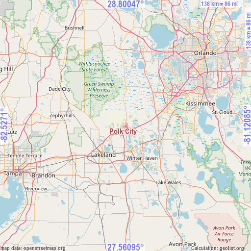
Polk City GPS coordinates[2]
28° 10' 57.036" North, 81° 49' 26.292" West
| Map corner | latitude | longitude |
|---|---|---|
| Upper-left | 28.80047°, | -82.5271° |
| Center: | 28.18251°, | -81.82397° |
| Lower-right: | 27.56095°, | -81.12085° |
| Map W x H: | 137.8×137.8 km | = 85.6×85.6mi |
| max Lat: | 71.29058° ⇑96.4% North |
| Polk City: | 28.18251° |
| min Lat: | ⇓3.6% South 19.06759° |
| min Long | Polk City | max Long |
| -171.73463° | -81.82397° | -66.98998° |
| W 66.2%⇐ | ⇒33.8% E |
Elevation
Elevation of Polk City is 56 m = 184 ft, and this is 238.8 m = 783 ft below average elevation for this country.
| Max E: |
3189 m = 10463 ft | 77.9% |
| Avg. | 294.8 m = 967 ft | |
| Polk City | 56 m = 184 ft | |
Min E: |
-60 m = -197 ft | 22.1% |
See also: United States elevation on elevation.city.
Geographical zone
Polk City is located in North temperate zone (between Tropic of Cancer and the Arctic Circle). Distance of this Northern Tropic circle is 527.7 km =327.9 mi to South.| Distance of | km | miles | from Polk City |
|---|---|---|---|
| North Pole | 6873.5 | 4271 | to North |
| Arctic Circle | 4267.6 | 2651.8 | to North |
| Tropic Cancer | 527.7 | 327.9 | to South |
| Equator | 3133.6 | 1947.1 | to South |


Nearby cities:
15 places around Polk City: (largest is in red/bold)
• Auburndale
13.5 km =8.4 mi,  165°
165°
• Combee Settlement
15.9 km =9.9 mi,  210°
210°
• Crystal Lake
18.3 km =11.4 mi, 206°
• Davenport
21.9 km =13.6 mi,  96°
96°
• Eagle Lake
23.6 km =14.7 mi,  163°
163°
• Four Corners
24.1 km =15 mi,  45°
45°
• Fussels Corner
14.7 km =9.1 mi,  194°
194°
• Gibsonia
16.5 km =10.3 mi,  242°
242°
• Haines City
21.4 km =13.3 mi,  110°
110°
• Inwood
17.2 km =10.7 mi, 160°
• Jan-Phyl Village
19.3 km =12 mi, 164°
• Kathleen
20.7 km =12.9 mi,  250°
250°
• Lake Alfred
14.1 km =8.8 mi,  135°
135°
• Lakeland
20.1 km =12.5 mi,  217°
217°
• Winter Haven
19.9 km =12.4 mi,  153°
153°
Sources, notices
• [Note1] Compared only with cities in United States existing in our database
• [Src1] Map data: © OpenStreetMap contributors (CC-BY-SA)
• [Src2] Other city data from geonames.org with taken over terms of usage.
• [Src3] Geographical zone / Annual Mean Temperature by Robert A. Rohde @ Wikipedia
