San Antonio geodata
San Antonio (Florida) is a populated place; located in United States in America/New_York (GMT-4) time zone. With population of 1,308 people, there are 14555 cities with bigger population in this country. Compared to other cities in United States, 96.2% of cities are located further ↑North; 64.7% of cities are located further ←West and 77.9% of cities have higher elevation than San Antonio. Note1


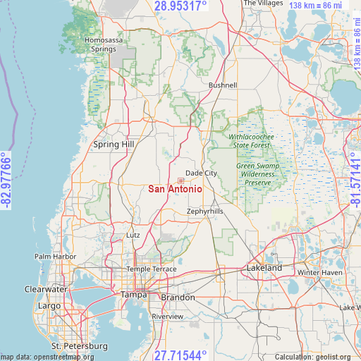
San Antonio GPS coordinates[2]
28° 20' 9.996" North, 82° 16' 28.308" West
| Map corner | latitude | longitude |
|---|---|---|
| Upper-left | 28.95317°, | -82.97766° |
| Center: | 28.33611°, | -82.27453° |
| Lower-right: | 27.71544°, | -81.57141° |
| Map W x H: | 137.6×137.6 km | = 85.5×85.5mi |
| max Lat: | 71.29058° ⇑96.2% North |
| San Antonio: | 28.33611° |
| min Lat: | ⇓3.8% South 19.06759° |
| min Long | San Antonio | max Long |
| -171.73463° | -82.27453° | -66.98998° |
| W 64.7%⇐ | ⇒35.3% E |
Elevation
Elevation of San Antonio is 56 m = 184 ft, and this is 238.8 m = 783 ft below average elevation for this country.
| Max E: |
3189 m = 10463 ft | 77.9% |
| Avg. | 294.8 m = 967 ft | |
| San Antonio | 56 m = 184 ft | |
Min E: |
-60 m = -197 ft | 22.1% |
See also: United States elevation on elevation.city.
Geographical zone
San Antonio is located in North temperate zone (between Tropic of Cancer and the Arctic Circle). Distance of this Northern Tropic circle is 544.8 km =338.5 mi to South.| Distance of | km | miles | from San Antonio |
|---|---|---|---|
| North Pole | 6856.4 | 4260.4 | to North |
| Arctic Circle | 4250.5 | 2641.1 | to North |
| Tropic Cancer | 544.8 | 338.5 | to South |
| Equator | 3150.7 | 1957.8 | to South |


Nearby cities:
15 places around San Antonio: (largest is in red/bold)
• Connerton
19.8 km =12.3 mi,  263°
263°
• Crystal Springs
20.7 km =12.9 mi,  146°
146°
• Dade City
8.3 km =5.2 mi,  67°
67°
• Dade City North
9.5 km =5.9 mi,  56°
56°
• Hill 'n Dale
20.6 km =12.8 mi,  353°
353°
• Lacoochee
17.6 km =10.9 mi,  34°
34°
• Masaryktown
21.4 km =13.3 mi,  303°
303°
• Pasadena Hills
7.9 km =4.9 mi,  141°
141°
• Ridge Manor
21.6 km =13.4 mi, 28°
• Saint Leo
1.6 km =1 mi,  85°
85°
• Wesley Chapel
11.9 km =7.4 mi,  205°
205°
• Zephyrhills
14.6 km =9.1 mi, 141°
• Zephyrhills North
14.2 km =8.8 mi,  131°
131°
• Zephyrhills South
15.9 km =9.9 mi, 148°
• Zephyrhills West
13.5 km =8.4 mi, 150°
Sources, notices
• [Note1] Compared only with cities in United States existing in our database
• [Src1] Map data: © OpenStreetMap contributors (CC-BY-SA)
• [Src2] Other city data from geonames.org with taken over terms of usage.
• [Src3] Geographical zone / Annual Mean Temperature by Robert A. Rohde @ Wikipedia
