Wesley Chapel geodata
Wesley Chapel (Florida) is a populated place; located in United States in America/New_York (GMT-4) time zone. With population of 44,092 people, there are 1081 cities with bigger population in this country. Compared to other cities in United States, 96.3% of cities are located further ↑North; 64.5% of cities are located further ←West and 82.6% of cities have higher elevation than Wesley Chapel. Note1


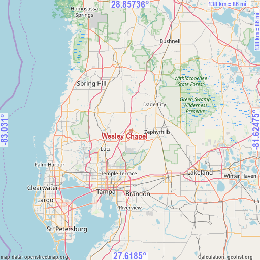
Wesley Chapel GPS coordinates[2]
28° 14' 23.028" North, 82° 19' 40.332" West
| Map corner | latitude | longitude |
|---|---|---|
| Upper-left | 28.85736°, | -83.031° |
| Center: | 28.23973°, | -82.32787° |
| Lower-right: | 27.6185°, | -81.62475° |
| Map W x H: | 137.7×137.7 km | = 85.6×85.6mi |
| max Lat: | 71.29058° ⇑96.3% North |
| Wesley Chapel: | 28.23973° |
| min Lat: | ⇓3.7% South 19.06759° |
| min Long | Wesley Chapel | max Long |
| -171.73463° | -82.32787° | -66.98998° |
| W 64.5%⇐ | ⇒35.5% E |
Elevation
Elevation of Wesley Chapel is 36 m = 118 ft, and this is 258.8 m = 849 ft below average elevation for this country.
| Max E: |
3189 m = 10463 ft | 82.6% |
| Avg. | 294.8 m = 967 ft | |
| Wesley Chapel | 36 m = 118 ft | |
Min E: |
-60 m = -197 ft | 17.4% |
See also: Wesley Chapel elevation on elevation.city.
Geographical zone
Wesley Chapel is located in North temperate zone (between Tropic of Cancer and the Arctic Circle). Distance of this Northern Tropic circle is 534 km =331.8 mi to South.| Distance of | km | miles | from Wesley Chapel |
|---|---|---|---|
| North Pole | 6867.1 | 4267 | to North |
| Arctic Circle | 4261.2 | 2647.8 | to North |
| Tropic Cancer | 534 | 331.8 | to South |
| Equator | 3140 | 1951.1 | to South |


Nearby cities:
15 places around Wesley Chapel: (largest is in red/bold)
• Connerton
16.7 km =10.4 mi,  299°
299°
• Crystal Springs
17.9 km =11.1 mi,  111°
111°
• Dade City
19 km =11.8 mi,  42°
42°
• Dade City North
20.7 km =12.9 mi, 39°
• Land O' Lakes
12.9 km =8 mi,  259°
259°
• Lutz
16.4 km =10.2 mi,  233°
233°
• Pasadena Hills
11.1 km =6.9 mi,  66°
66°
• Pebble Creek
10.3 km =6.4 mi,  189°
189°
• Saint Leo
12.8 km =8 mi,  32°
32°
• San Antonio
11.9 km =7.4 mi, 25°
• Thonotosassa
20 km =12.4 mi,  172°
172°
• Zephyrhills
14.4 km =8.9 mi,  92°
92°
• Zephyrhills North
16 km =9.9 mi, 85°
• Zephyrhills South
13.9 km =8.6 mi,  101°
101°
• Zephyrhills West
12 km =7.5 mi, 94°
Sources, notices
• [Note1] Compared only with cities in United States existing in our database
• [Src1] Map data: © OpenStreetMap contributors (CC-BY-SA)
• [Src2] Other city data from geonames.org with taken over terms of usage.
• [Src3] Geographical zone / Annual Mean Temperature by Robert A. Rohde @ Wikipedia
