Connerton geodata
Connerton (Florida) is a populated place; located in United States in America/New_York (GMT-4) time zone. With population of 2,116 people, there are 11568 cities with bigger population in this country. Compared to other cities in United States, 96.2% of cities are located further ↑North; 63.9% of cities are located further ←West and 85.8% of cities have higher elevation than Connerton. Note1


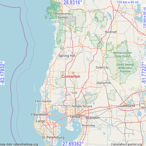
Connerton GPS coordinates[2]
28° 18' 51.876" North, 82° 28' 31.404" West
| Map corner | latitude | longitude |
|---|---|---|
| Upper-left | 28.9316°, | -83.17852° |
| Center: | 28.31441°, | -82.47539° |
| Lower-right: | 27.69362°, | -81.77227° |
| Map W x H: | 137.7×137.7 km | = 85.6×85.6mi |
| max Lat: | 71.29058° ⇑96.2% North |
| Connerton: | 28.31441° |
| min Lat: | ⇓3.8% South 19.06759° |
| min Long | Connerton | max Long |
| -171.73463° | -82.47539° | -66.98998° |
| W 63.9%⇐ | ⇒36.1% E |
Elevation
Elevation of Connerton is 26 m = 85 ft, and this is 268.8 m = 882 ft below average elevation for this country.
| Max E: |
3189 m = 10463 ft | 85.8% |
| Avg. | 294.8 m = 967 ft | |
| Connerton | 26 m = 85 ft | |
Min E: |
-60 m = -197 ft | 14.2% |
See also: United States elevation on elevation.city.
Geographical zone
Connerton is located in North temperate zone (between Tropic of Cancer and the Arctic Circle). Distance of this Northern Tropic circle is 542.3 km =337 mi to South.| Distance of | km | miles | from Connerton |
|---|---|---|---|
| North Pole | 6858.8 | 4261.9 | to North |
| Arctic Circle | 4252.9 | 2642.6 | to North |
| Tropic Cancer | 542.3 | 337 | to South |
| Equator | 3148.3 | 1956.3 | to South |


Nearby cities:
15 places around Connerton: (largest is in red/bold)
• Bayonet Point
20.4 km =12.7 mi,  273°
273°
• Cheval
18.8 km =11.7 mi,  191°
191°
• Garden Grove
18.9 km =11.7 mi,  12°
12°
• Heritage Pines
18.8 km =11.7 mi,  310°
310°
• Jasmine Estates
21.2 km =13.2 mi,  263°
263°
• Land O' Lakes
10.8 km =6.7 mi,  170°
170°
• Lutz
18.2 km =11.3 mi,  175°
175°
• Masaryktown
14.3 km =8.9 mi, 7°
• Meadow Oaks
13 km =8.1 mi,  285°
285°
• Odessa
17.6 km =10.9 mi,  220°
220°
• Quail Ridge
8.7 km =5.4 mi,  296°
296°
• San Antonio
19.8 km =12.3 mi,  83°
83°
• Shady Hills
12.5 km =7.8 mi,  328°
328°
• Spring Hill
18.7 km =11.6 mi,  344°
344°
• Wesley Chapel
16.7 km =10.4 mi,  119°
119°
Sources, notices
• [Note1] Compared only with cities in United States existing in our database
• [Src1] Map data: © OpenStreetMap contributors (CC-BY-SA)
• [Src2] Other city data from geonames.org with taken over terms of usage.
• [Src3] Geographical zone / Annual Mean Temperature by Robert A. Rohde @ Wikipedia
