Southwest Ranches geodata
Southwest Ranches (Florida) is a populated place; located in United States in America/New_York (GMT-4) time zone. With population of 7,852 people, there are 5355 cities with bigger population in this country. Compared to other cities in United States, 98.8% of cities are located further ↑North; 71.5% of cities are located further ←West and 96.6% of cities have higher elevation than Southwest Ranches. Note1


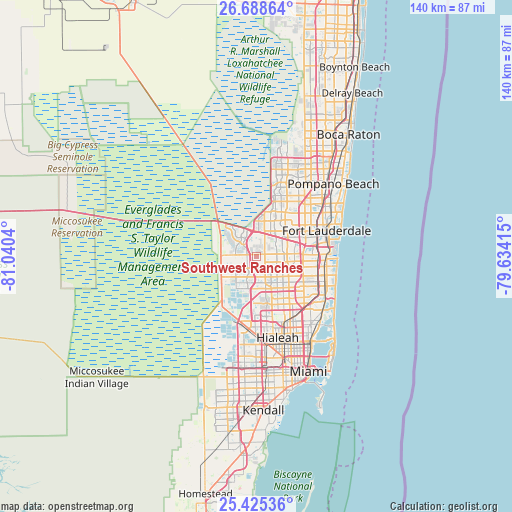
Southwest Ranches GPS coordinates[2]
26° 3' 31.32" North, 80° 20' 14.172" West
| Map corner | latitude | longitude |
|---|---|---|
| Upper-left | 26.68864°, | -81.0404° |
| Center: | 26.0587°, | -80.33727° |
| Lower-right: | 25.42536°, | -79.63415° |
| Map W x H: | 140.5×140.5 km | = 87.3×87.3mi |
| max Lat: | 71.29058° ⇑98.8% North |
| Southwest Ranches: | 26.0587° |
| min Lat: | ⇓1.2% South 19.06759° |
| min Long | Southwest Ranch | max Long |
| -171.73463° | -80.33727° | -66.98998° |
| W 71.5%⇐ | ⇒28.5% E |
Elevation
Elevation of Southwest Ranches is 7 m = 23 ft, and this is 287.8 m = 944 ft below average elevation for this country.
| Max E: |
3189 m = 10463 ft | 96.6% |
| Avg. | 294.8 m = 967 ft | |
| Southwest Ranches | 7 m = 23 ft | |
Min E: |
-60 m = -197 ft | 3.4% |
See also: United States elevation on elevation.city.
Geographical zone
Southwest Ranches is located in North temperate zone (between Tropic of Cancer and the Arctic Circle). Distance of this Northern Tropic circle is 291.5 km =181.1 mi to South.| Distance of | km | miles | from Southwest Ranches |
|---|---|---|---|
| North Pole | 7109.6 | 4417.7 | to North |
| Arctic Circle | 4503.7 | 2798.5 | to North |
| Tropic Cancer | 291.5 | 181.1 | to South |
| Equator | 2897.5 | 1800.4 | to South |


Nearby cities:
15 places around Southwest Ranches: (largest is in red/bold)
• Broadview Park
13.6 km =8.5 mi,  70°
70°
• Cooper City
6.5 km =4 mi,  91°
91°
• Country Club
12.5 km =7.8 mi,  170°
170°
• Davie
10.4 km =6.5 mi, 87°
• Lake Lucerne
14.1 km =8.8 mi,  137°
137°
• Lauderhill
15.3 km =9.5 mi,  53°
53°
• Melrose Park
15.6 km =9.7 mi, 67°
• Miramar
13.2 km =8.2 mi,  127°
127°
• Palm Springs North
13.7 km =8.5 mi,  178°
178°
• Pembroke Pines
12.9 km =8 mi,  118°
118°
• Pine Island Ridge
7.5 km =4.7 mi,  57°
57°
• Plantation
13.5 km =8.4 mi, 51°
• Sunshine Ranches
1.6 km =1 mi,  149°
149°
• West Hollywood
15.9 km =9.9 mi,  105°
105°
• Weston
7.8 km =4.8 mi,  306°
306°
Sources, notices
• [Note1] Compared only with cities in United States existing in our database
• [Src1] Map data: © OpenStreetMap contributors (CC-BY-SA)
• [Src2] Other city data from geonames.org with taken over terms of usage.
• [Src3] Geographical zone / Annual Mean Temperature by Robert A. Rohde @ Wikipedia
