Weston geodata
Weston (Florida) is a populated place; located in United States in America/New_York (GMT-4) time zone. With population of 69,959 people, there are 596 cities with bigger population in this country. Compared to other cities in United States, 98.7% of cities are located further ↑North; 71.2% of cities are located further ←West and 96.6% of cities have higher elevation than Weston. Note1


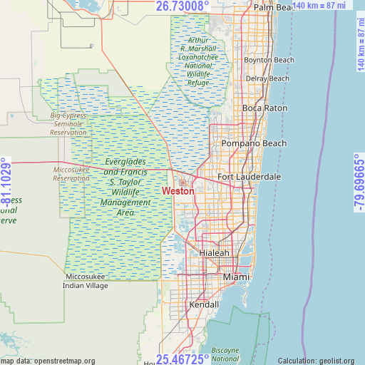
Weston GPS coordinates[2]
26° 6' 1.332" North, 80° 23' 59.172" West
| Map corner | latitude | longitude |
|---|---|---|
| Upper-left | 26.73008°, | -81.1029° |
| Center: | 26.10037°, | -80.39977° |
| Lower-right: | 25.46725°, | -79.69665° |
| Map W x H: | 140.4×140.4 km | = 87.2×87.2mi |
| max Lat: | 71.29058° ⇑98.7% North |
| Weston: | 26.10037° |
| min Lat: | ⇓1.3% South 19.06759° |
| min Long | Weston | max Long |
| -171.73463° | -80.39977° | -66.98998° |
| W 71.2%⇐ | ⇒28.8% E |
Elevation
Elevation of Weston is 7 m = 23 ft, and this is 287.8 m = 944 ft below average elevation for this country.
| Max E: |
3189 m = 10463 ft | 96.6% |
| Avg. | 294.8 m = 967 ft | |
| Weston | 7 m = 23 ft | |
Min E: |
-60 m = -197 ft | 3.4% |
See also: Weston elevation on elevation.city.
Geographical zone
Weston is located in North temperate zone (between Tropic of Cancer and the Arctic Circle). Distance of this Northern Tropic circle is 296.2 km =184.1 mi to South.| Distance of | km | miles | from Weston |
|---|---|---|---|
| North Pole | 7105 | 4414.8 | to North |
| Arctic Circle | 4499.1 | 2795.6 | to North |
| Tropic Cancer | 296.2 | 184.1 | to South |
| Equator | 2902.1 | 1803.3 | to South |


Nearby cities:
15 places around Weston: (largest is in red/bold)
• Broadview Park
19.1 km =11.9 mi,  90°
90°
• Broward Estates
20.8 km =12.9 mi,  82°
82°
• Cooper City
13.7 km =8.5 mi,  110°
110°
• Country Club
18.8 km =11.7 mi,  153°
153°
• Davie
17.2 km =10.7 mi,  104°
104°
• Lauderdale Lakes
20.5 km =12.7 mi,  68°
68°
• Lauderhill
19.1 km =11.9 mi, 76°
• Melrose Park
20.7 km =12.9 mi, 85°
• Palm Springs North
19.5 km =12.1 mi,  160°
160°
• Pembroke Pines
20.6 km =12.8 mi,  121°
121°
• Pine Island Ridge
12.6 km =7.8 mi, 92°
• Plantation
17.2 km =10.7 mi, 77°
• Southwest Ranches
7.8 km =4.8 mi,  126°
126°
• Sunshine Ranches
9.3 km =5.8 mi, 130°
• Tamarac
19.5 km =12.1 mi,  50°
50°
Sources, notices
• [Note1] Compared only with cities in United States existing in our database
• [Src1] Map data: © OpenStreetMap contributors (CC-BY-SA)
• [Src2] Other city data from geonames.org with taken over terms of usage.
• [Src3] Geographical zone / Annual Mean Temperature by Robert A. Rohde @ Wikipedia
