Wewahitchka geodata
Wewahitchka (Florida) is a populated place; located in United States in America/Chicago (GMT-5) time zone. With population of 1,995 people, there are 11954 cities with bigger population in this country. Compared to other cities in United States, 93.1% of cities are located further ↑North; 55.4% of cities are located further ←West and 89.5% of cities have higher elevation than Wewahitchka. Note1


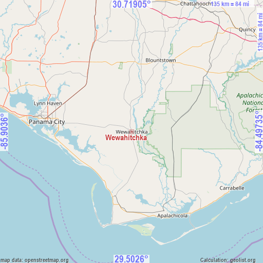
Wewahitchka GPS coordinates[2]
30° 6' 45.72" North, 85° 12' 1.692" West
| Map corner | latitude | longitude |
|---|---|---|
| Upper-left | 30.71905°, | -85.9036° |
| Center: | 30.1127°, | -85.20047° |
| Lower-right: | 29.5026°, | -84.49735° |
| Map W x H: | 135.3×135.3 km | = 84.1×84.1mi |
| max Lat: | 71.29058° ⇑93.1% North |
| Wewahitchka: | 30.1127° |
| min Lat: | ⇓6.9% South 19.06759° |
| min Long | Wewahitchka | max Long |
| -171.73463° | -85.20047° | -66.98998° |
| W 55.4%⇐ | ⇒44.6% E |
Elevation
Elevation of Wewahitchka is 17 m = 56 ft, and this is 277.8 m = 911 ft below average elevation for this country.
| Max E: |
3189 m = 10463 ft | 89.5% |
| Avg. | 294.8 m = 967 ft | |
| Wewahitchka | 17 m = 56 ft | |
Min E: |
-60 m = -197 ft | 10.5% |
See also: United States elevation on elevation.city.
Geographical zone
Wewahitchka is located in North temperate zone (between Tropic of Cancer and the Arctic Circle). Distance of this Northern Tropic circle is 742.3 km =461.2 mi to South.| Distance of | km | miles | from Wewahitchka |
|---|---|---|---|
| North Pole | 6658.8 | 4137.6 | to North |
| Arctic Circle | 4053 | 2518.4 | to North |
| Tropic Cancer | 742.3 | 461.2 | to South |
| Equator | 3348.2 | 2080.5 | to South |


Nearby cities:
15 places around Wewahitchka: (largest is in red/bold)
• Apalachicola
47.7 km =29.6 mi,  154°
154°
• Blountstown
39.6 km =24.6 mi,  21°
21°
• Bristol
41.5 km =25.8 mi,  31°
31°
• Callaway
35.8 km =22.2 mi,  277°
277°
• Cedar Grove
41.4 km =25.7 mi, 279°
• Hiland Park
42.2 km =26.2 mi, 283°
• Lynn Haven
45.5 km =28.3 mi,  288°
288°
• Mexico Beach
28 km =17.4 mi,  229°
229°
• Panama City
44.5 km =27.7 mi, 276°
• Parker
38.8 km =24.1 mi,  273°
273°
• Port Saint Joe
34.9 km =21.7 mi,  196°
196°
• Pretty Bayou
48.6 km =30.2 mi, 281°
• Springfield
39.8 km =24.7 mi, 276°
• Tyndall Air Force Base
39.3 km =24.4 mi, 265°
• Youngstown
36.1 km =22.4 mi,  320°
320°
Sources, notices
• [Note1] Compared only with cities in United States existing in our database
• [Src1] Map data: © OpenStreetMap contributors (CC-BY-SA)
• [Src2] Other city data from geonames.org with taken over terms of usage.
• [Src3] Geographical zone / Annual Mean Temperature by Robert A. Rohde @ Wikipedia
