Apalachicola geodata
Apalachicola (Florida) is a seat of a second-order administrative division; located in United States in America/New_York (GMT-4) time zone. With population of 2,281 people, there are 11131 cities with bigger population in this country. Compared to other cities in United States, 94% of cities are located further ↑North; 55.9% of cities are located further ←West and 93% of cities have higher elevation than Apalachicola. Note1


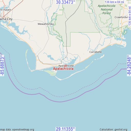
Apalachicola GPS coordinates[2]
29° 43' 33.6" North, 84° 59' 8.16" West
| Map corner | latitude | longitude |
|---|---|---|
| Upper-left | 30.33473°, | -85.68873° |
| Center: | 29.726°, | -84.9856° |
| Lower-right: | 29.11355°, | -84.28248° |
| Map W x H: | 135.8×135.8 km | = 84.4×84.4mi |
| max Lat: | 71.29058° ⇑94% North |
| Apalachicola: | 29.726° |
| min Lat: | ⇓6% South 19.06759° |
| min Long | Apalachicola | max Long |
| -171.73463° | -84.9856° | -66.98998° |
| W 55.9%⇐ | ⇒44.1% E |
Elevation
Elevation of Apalachicola is 11 m = 36 ft, and this is 283.8 m = 931 ft below average elevation for this country.
| Max E: |
3189 m = 10463 ft | 93% |
| Avg. | 294.8 m = 967 ft | |
| Apalachicola | 11 m = 36 ft | |
Min E: |
-60 m = -197 ft | 7% |
See also: United States elevation on elevation.city.
Geographical zone
Apalachicola is located in North temperate zone (between Tropic of Cancer and the Arctic Circle). Distance of this Northern Tropic circle is 699.3 km =434.5 mi to South.| Distance of | km | miles | from Apalachicola |
|---|---|---|---|
| North Pole | 6701.8 | 4164.3 | to North |
| Arctic Circle | 4096 | 2545.1 | to North |
| Tropic Cancer | 699.3 | 434.5 | to South |
| Equator | 3305.2 | 2053.8 | to South |


Nearby cities:
15 places around Apalachicola: (largest is in red/bold)
• Blountstown
80 km =49.7 mi,  355°
355°
• Bristol
78.6 km =48.8 mi,  0°
0°
• Callaway
73.6 km =45.7 mi,  310°
310°
• Carrabelle
34.1 km =21.2 mi,  65°
65°
• Cedar Grove
79 km =49.1 mi, 308°
• Crawfordville
77.2 km =48 mi,  49°
49°
• Eastpoint
10.4 km =6.5 mi,  83°
83°
• Hosford
75.7 km =47 mi,  13°
13°
• Mexico Beach
48.6 km =30.2 mi,  300°
300°
• Panacea
67.2 km =41.8 mi,  59°
59°
• Parker
74.6 km =46.4 mi, 307°
• Port Saint Joe
32.1 km =19.9 mi,  287°
287°
• Springfield
76.8 km =47.7 mi, 308°
• Tyndall Air Force Base
72 km =44.7 mi, 303°
• Wewahitchka
47.7 km =29.6 mi,  334°
334°
Sources, notices
• [Note1] Compared only with cities in United States existing in our database
• [Src1] Map data: © OpenStreetMap contributors (CC-BY-SA)
• [Src2] Other city data from geonames.org with taken over terms of usage.
• [Src3] Geographical zone / Annual Mean Temperature by Robert A. Rohde @ Wikipedia
