Rockmart geodata
Rockmart (Georgia) is a populated place; located in United States in America/New_York (GMT-4) time zone. With population of 4,300 people, there are 7865 cities with bigger population in this country. Compared to other cities in United States, 80.2% of cities are located further ↑North; 55.8% of cities are located further ←West and 59.9% of cities have lower elevation than Rockmart. Note1


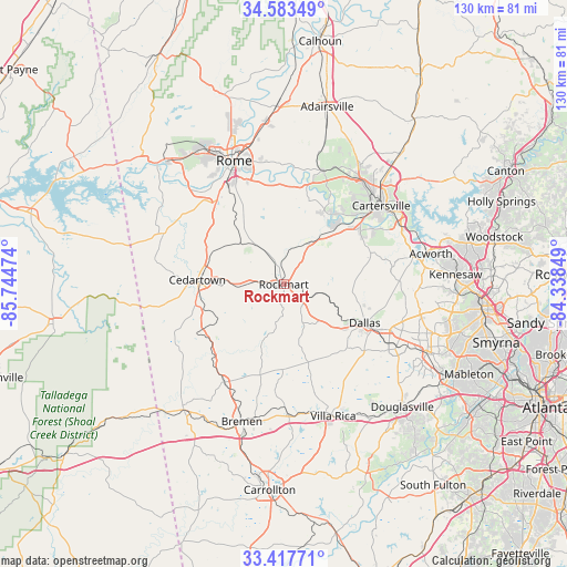
Rockmart GPS coordinates[2]
34° 0' 9.36" North, 85° 2' 29.796" West
| Map corner | latitude | longitude |
|---|---|---|
| Upper-left | 34.58349°, | -85.74474° |
| Center: | 34.0026°, | -85.04161° |
| Lower-right: | 33.41771°, | -84.33849° |
| Map W x H: | 129.6×129.6 km | = 80.5×80.5mi |
| max Lat: | 71.29058° ⇑80.2% North |
| Rockmart: | 34.0026° |
| min Lat: | ⇓19.8% South 19.06759° |
| min Long | Rockmart | max Long |
| -171.73463° | -85.04161° | -66.98998° |
| W 55.8%⇐ | ⇒44.2% E |
Elevation
Elevation of Rockmart is 239 m = 784 ft, and this is 55.8 m = 183 ft below average elevation for this country.
| Max E: |
3189 m = 10463 ft | 40.1% |
| Avg. | 294.8 m = 967 ft | |
| Rockmart | 239 m = 784 ft | |
Min E: |
-60 m = -197 ft | 59.9% |
See also: United States elevation on elevation.city.
Geographical zone
Rockmart is located in North temperate zone (between Tropic of Cancer and the Arctic Circle). Distance of this Northern Tropic circle is 1174.8 km =730 mi to South.| Distance of | km | miles | from Rockmart |
|---|---|---|---|
| North Pole | 6226.3 | 3868.8 | to North |
| Arctic Circle | 3620.4 | 2249.6 | to North |
| Tropic Cancer | 1174.8 | 730 | to South |
| Equator | 3780.7 | 2349.2 | to South |


Nearby cities:
15 places around Rockmart: (largest is in red/bold)
• Aragon
5 km =3.1 mi,  344°
344°
• Bremen
32.7 km =20.3 mi,  197°
197°
• Buchanan
26 km =16.2 mi,  211°
211°
• Cartersville
28.5 km =17.7 mi,  50°
50°
• Cave Spring
29.6 km =18.4 mi,  293°
293°
• Cedartown
19.8 km =12.3 mi,  272°
272°
• Dallas
20.5 km =12.7 mi,  115°
115°
• Emerson
29.8 km =18.5 mi,  62°
62°
• Euharlee
18.7 km =11.6 mi,  32°
32°
• Hiram
29.4 km =18.3 mi, 118°
• Kingston
27.6 km =17.1 mi,  18°
18°
• Lindale
23.9 km =14.9 mi,  329°
329°
• Rome
30.5 km =19 mi, 338°
• Temple
29.5 km =18.3 mi,  178°
178°
• Villa Rica
32.1 km =19.9 mi,  159°
159°
Sources, notices
• [Note1] Compared only with cities in United States existing in our database
• [Src1] Map data: © OpenStreetMap contributors (CC-BY-SA)
• [Src2] Other city data from geonames.org with taken over terms of usage.
• [Src3] Geographical zone / Annual Mean Temperature by Robert A. Rohde @ Wikipedia
