Crawford geodata
Crawford (Georgia) is a populated place; located in United States in America/New_York (GMT-4) time zone. With population of 826 people, there are 17560 cities with bigger population in this country. Compared to other cities in United States, 81.1% of cities are located further ↑North; 61.6% of cities are located further ←West and 60.1% of cities have lower elevation than Crawford. Note1


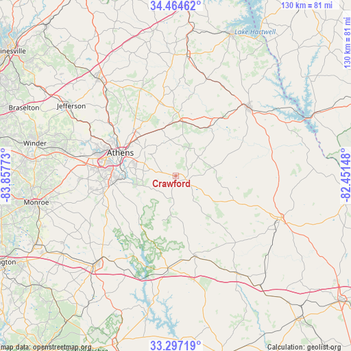
Crawford GPS coordinates[2]
33° 52' 58.44" North, 83° 9' 16.56" West
| Map corner | latitude | longitude |
|---|---|---|
| Upper-left | 34.46462°, | -83.85773° |
| Center: | 33.8829°, | -83.1546° |
| Lower-right: | 33.29719°, | -82.45148° |
| Map W x H: | 129.8×129.8 km | = 80.7×80.7mi |
| max Lat: | 71.29058° ⇑81.1% North |
| Crawford: | 33.8829° |
| min Lat: | ⇓18.9% South 19.06759° |
| min Long | Crawford | max Long |
| -171.73463° | -83.1546° | -66.98998° |
| W 61.6%⇐ | ⇒38.4% E |
Elevation
Elevation of Crawford is 240 m = 787 ft, and this is 54.8 m = 180 ft below average elevation for this country.
| Max E: |
3189 m = 10463 ft | 39.9% |
| Avg. | 294.8 m = 967 ft | |
| Crawford | 240 m = 787 ft | |
Min E: |
-60 m = -197 ft | 60.1% |
See also: United States elevation on elevation.city.
Geographical zone
Crawford is located in North temperate zone (between Tropic of Cancer and the Arctic Circle). Distance of this Northern Tropic circle is 1161.5 km =721.7 mi to South.| Distance of | km | miles | from Crawford |
|---|---|---|---|
| North Pole | 6239.6 | 3877.1 | to North |
| Arctic Circle | 3633.7 | 2257.9 | to North |
| Tropic Cancer | 1161.5 | 721.7 | to South |
| Equator | 3767.4 | 2341 | to South |


Nearby cities:
15 places around Crawford: (largest is in red/bold)
• Athens
22.4 km =13.9 mi,  292°
292°
• Bogart
35.8 km =22.2 mi,  281°
281°
• Bowman
37.6 km =23.4 mi,  17°
17°
• Colbert
18 km =11.2 mi,  342°
342°
• Comer
20.3 km =12.6 mi,  7°
7°
• Country Club Estates
26.3 km =16.3 mi,  296°
296°
• Danielsville
27.5 km =17.1 mi,  347°
347°
• Elberton
36.6 km =22.7 mi,  46°
46°
• Greensboro
34.3 km =21.3 mi,  184°
184°
• Lexington
4.2 km =2.6 mi,  110°
110°
• Nicholson
36.2 km =22.5 mi,  315°
315°
• North High Shoals
33.2 km =20.6 mi,  257°
257°
• Union Point
30.6 km =19 mi,  166°
166°
• Watkinsville
23.6 km =14.7 mi, 264°
• Winterville
14.8 km =9.2 mi,  309°
309°
Sources, notices
• [Note1] Compared only with cities in United States existing in our database
• [Src1] Map data: © OpenStreetMap contributors (CC-BY-SA)
• [Src2] Other city data from geonames.org with taken over terms of usage.
• [Src3] Geographical zone / Annual Mean Temperature by Robert A. Rohde @ Wikipedia
