Danielsville geodata
Danielsville (Georgia) is a seat of a second-order administrative division; located in United States in America/New_York (GMT-4) time zone. With population of 577 people, there are 19951 cities with bigger population in this country. Compared to other cities in United States, 79.4% of cities are located further ↑North; 61.4% of cities are located further ←West and 56.9% of cities have lower elevation than Danielsville. Note1


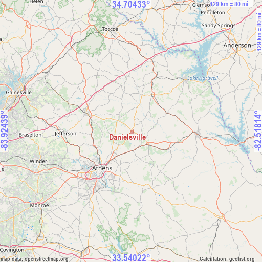
Danielsville GPS coordinates[2]
34° 7' 27.408" North, 83° 13' 16.536" West
| Map corner | latitude | longitude |
|---|---|---|
| Upper-left | 34.70433°, | -83.92439° |
| Center: | 34.12428°, | -83.22126° |
| Lower-right: | 33.54022°, | -82.51814° |
| Map W x H: | 129.4×129.4 km | = 80.4×80.4mi |
| max Lat: | 71.29058° ⇑79.4% North |
| Danielsville: | 34.12428° |
| min Lat: | ⇓20.6% South 19.06759° |
| min Long | Danielsville | max Long |
| -171.73463° | -83.22126° | -66.98998° |
| W 61.4%⇐ | ⇒38.6% E |
Elevation
Elevation of Danielsville is 226 m = 741 ft, and this is 68.8 m = 226 ft below average elevation for this country.
| Max E: |
3189 m = 10463 ft | 43.1% |
| Avg. | 294.8 m = 967 ft | |
| Danielsville | 226 m = 741 ft | |
Min E: |
-60 m = -197 ft | 56.9% |
See also: United States elevation on elevation.city.
Geographical zone
Danielsville is located in North temperate zone (between Tropic of Cancer and the Arctic Circle). Distance of this Northern Tropic circle is 1188.3 km =738.4 mi to South.| Distance of | km | miles | from Danielsville |
|---|---|---|---|
| North Pole | 6212.8 | 3860.5 | to North |
| Arctic Circle | 3606.9 | 2241.2 | to North |
| Tropic Cancer | 1188.3 | 738.4 | to South |
| Equator | 3794.3 | 2357.7 | to South |


Nearby cities:
15 places around Danielsville: (largest is in red/bold)
• Arcade
31.8 km =19.8 mi,  260°
260°
• Athens
23.2 km =14.4 mi,  218°
218°
• Bowman
19.7 km =12.2 mi,  62°
62°
• Canon
26.7 km =16.6 mi,  22°
22°
• Carnesville
27.3 km =17 mi,  357°
357°
• Colbert
9.6 km =6 mi,  175°
175°
• Comer
11.1 km =6.9 mi,  127°
127°
• Commerce
23.4 km =14.5 mi,  292°
292°
• Country Club Estates
22.9 km =14.2 mi,  229°
229°
• Crawford
27.5 km =17.1 mi,  167°
167°
• Franklin Springs
19.2 km =11.9 mi, 21°
• Lexington
30 km =18.6 mi,  160°
160°
• Nicholson
19.4 km =12.1 mi,  266°
266°
• Royston
20.8 km =12.9 mi,  29°
29°
• Winterville
18.3 km =11.4 mi,  196°
196°
Sources, notices
• [Note1] Compared only with cities in United States existing in our database
• [Src1] Map data: © OpenStreetMap contributors (CC-BY-SA)
• [Src2] Other city data from geonames.org with taken over terms of usage.
• [Src3] Geographical zone / Annual Mean Temperature by Robert A. Rohde @ Wikipedia
