Athens geodata
Athens (Georgia) is a seat of a second-order administrative division; located in United States in America/New_York (GMT-4) time zone. With population of 116,714 people, there are 271 cities with bigger population in this country. Compared to other cities in United States, 80.5% of cities are located further ↑North; 61% of cities are located further ←West and 58.4% of cities have lower elevation than Athens. Note1


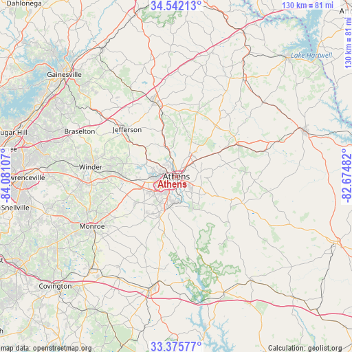
Athens GPS coordinates[2]
33° 57' 39.42" North, 83° 22' 40.584" West
| Map corner | latitude | longitude |
|---|---|---|
| Upper-left | 34.54213°, | -84.08107° |
| Center: | 33.96095°, | -83.37794° |
| Lower-right: | 33.37577°, | -82.67482° |
| Map W x H: | 129.7×129.7 km | = 80.6×80.6mi |
| max Lat: | 71.29058° ⇑80.5% North |
| Athens: | 33.96095° |
| min Lat: | ⇓19.5% South 19.06759° |
| min Long | Athens | max Long |
| -171.73463° | -83.37794° | -66.98998° |
| W 61%⇐ | ⇒39% E |
Elevation
Elevation of Athens is 232 m = 761 ft, and this is 62.8 m = 206 ft below average elevation for this country.
| Max E: |
3189 m = 10463 ft | 41.6% |
| Avg. | 294.8 m = 967 ft | |
| Athens | 232 m = 761 ft | |
Min E: |
-60 m = -197 ft | 58.4% |
See also: Athens elevation on elevation.city.
Geographical zone
Athens is located in North temperate zone (between Tropic of Cancer and the Arctic Circle). Distance of this Northern Tropic circle is 1170.2 km =727.1 mi to South.| Distance of | km | miles | from Athens |
|---|---|---|---|
| North Pole | 6231 | 3871.8 | to North |
| Arctic Circle | 3625.1 | 2252.5 | to North |
| Tropic Cancer | 1170.2 | 727.1 | to South |
| Equator | 3776.1 | 2346.4 | to South |


Nearby cities:
15 places around Athens: (largest is in red/bold)
• Arcade
21.3 km =13.2 mi,  307°
307°
• Bogart
14.5 km =9 mi,  264°
264°
• Colbert
17.5 km =10.9 mi,  60°
60°
• Comer
25.9 km =16.1 mi, 63°
• Commerce
28 km =17.4 mi,  344°
344°
• Country Club Estates
4.3 km =2.7 mi,  317°
317°
• Crawford
22.4 km =13.9 mi,  112°
112°
• Danielsville
23.2 km =14.4 mi,  38°
38°
• Jefferson
24.9 km =15.5 mi, 314°
• Lexington
26.6 km =16.5 mi, 112°
• Nicholson
17.7 km =11 mi, 343°
• North High Shoals
19.6 km =12.2 mi,  217°
217°
• Statham
20.2 km =12.6 mi,  271°
271°
• Watkinsville
11.3 km =7 mi,  194°
194°
• Winterville
9.2 km =5.7 mi,  85°
85°
Sources, notices
• [Note1] Compared only with cities in United States existing in our database
• [Src1] Map data: © OpenStreetMap contributors (CC-BY-SA)
• [Src2] Other city data from geonames.org with taken over terms of usage.
• [Src3] Geographical zone / Annual Mean Temperature by Robert A. Rohde @ Wikipedia
