Duluth geodata
Duluth (Georgia) is a populated place; located in United States in America/New_York (GMT-4) time zone. With population of 29,193 people, there are 1709 cities with bigger population in this country. Compared to other cities in United States, 80.2% of cities are located further ↑North; 58.8% of cities are located further ←West and 78% of cities have lower elevation than Duluth. Note1


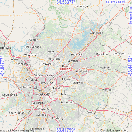
Duluth GPS coordinates[2]
34° 0' 10.368" North, 84° 8' 40.704" West
| Map corner | latitude | longitude |
|---|---|---|
| Upper-left | 34.58377°, | -84.84777° |
| Center: | 34.00288°, | -84.14464° |
| Lower-right: | 33.41799°, | -83.44152° |
| Map W x H: | 129.6×129.6 km | = 80.5×80.5mi |
| max Lat: | 71.29058° ⇑80.2% North |
| Duluth: | 34.00288° |
| min Lat: | ⇓19.8% South 19.06759° |
| min Long | Duluth | max Long |
| -171.73463° | -84.14464° | -66.98998° |
| W 58.8%⇐ | ⇒41.2% E |
Elevation
Elevation of Duluth is 336 m = 1102 ft, and this is 41.2 m = 135 ft above average elevation for this country.
| Max E: |
3189 m = 10463 ft | 22% |
| Duluth | 336 m 1102 ft | |
| Avg. | 294.8 m = 967 ft | |
Min E: |
-60 m = -197 ft | 78% |
See also: United States elevation on elevation.city.
Geographical zone
Duluth is located in North temperate zone (between Tropic of Cancer and the Arctic Circle). Distance of this Northern Tropic circle is 1174.8 km =730 mi to South.| Distance of | km | miles | from Duluth |
|---|---|---|---|
| North Pole | 6226.3 | 3868.8 | to North |
| Arctic Circle | 3620.4 | 2249.6 | to North |
| Tropic Cancer | 1174.8 | 730 | to South |
| Equator | 3780.8 | 2349.3 | to South |


Nearby cities:
15 places around Duluth: (largest is in red/bold)
• Alpharetta
16 km =9.9 mi,  300°
300°
• Berkeley Lake
4.4 km =2.7 mi,  241°
241°
• Buford
18.4 km =11.4 mi,  44°
44°
• Chamblee
18.8 km =11.7 mi,  229°
229°
• Doraville
17.3 km =10.7 mi, 227°
• Dunwoody
18.6 km =11.6 mi,  250°
250°
• Johns Creek
5.8 km =3.6 mi, 300°
• Lawrenceville
15.4 km =9.6 mi,  109°
109°
• Lilburn
12.5 km =7.8 mi,  179°
179°
• Mountain Park
17.7 km =11 mi, 175°
• Norcross
9.3 km =5.8 mi,  222°
222°
• Peachtree Corners
8 km =5 mi, 242°
• Sugar Hill
15.4 km =9.6 mi, 41°
• Suwanee
8.7 km =5.4 mi,  51°
51°
• Tucker
17.8 km =11.1 mi,  202°
202°
Sources, notices
• [Note1] Compared only with cities in United States existing in our database
• [Src1] Map data: © OpenStreetMap contributors (CC-BY-SA)
• [Src2] Other city data from geonames.org with taken over terms of usage.
• [Src3] Geographical zone / Annual Mean Temperature by Robert A. Rohde @ Wikipedia
