Alpharetta geodata
Alpharetta (Georgia) is a populated place; located in United States in America/New_York (GMT-4) time zone. With population of 63,693 people, there are 681 cities with bigger population in this country. Compared to other cities in United States, 79.7% of cities are located further ↑North; 58.3% of cities are located further ←West and 79.5% of cities have lower elevation than Alpharetta. Note1


Alpharetta GPS coordinates[2]
34° 4' 31.368" North, 84° 17' 38.724" West
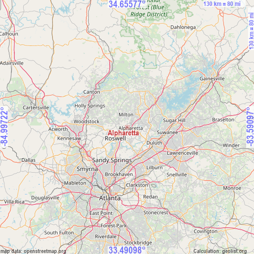
| Map corner | latitude | longitude |
|---|---|---|
| Upper-left | 34.65577°, | -84.99722° |
| Center: | 34.07538°, | -84.29409° |
| Lower-right: | 33.49098°, | -83.59097° |
| Map W x H: | 129.5×129.5 km | = 80.5×80.5mi |
| max Lat: | 71.29058° ⇑79.7% North |
| Alpharetta: | 34.07538° |
| min Lat: | ⇓20.3% South 19.06759° |
| min Long | Alpharetta | max Long |
| -171.73463° | -84.29409° | -66.98998° |
| W 58.3%⇐ | ⇒41.7% E |
Elevation
Elevation of Alpharetta is 348 m = 1142 ft, and this is 53.2 m = 175 ft above average elevation for this country.
| Max E: |
3189 m = 10463 ft | 20.5% |
| Alpharetta | 348 m 1142 ft | |
| Avg. | 294.8 m = 967 ft | |
Min E: |
-60 m = -197 ft | 79.5% |
See also: Alpharetta elevation on elevation.city.
Geographical zone
Alpharetta is located in North temperate zone (between Tropic of Cancer and the Arctic Circle). Distance of this Northern Tropic circle is 1182.9 km =735 mi to South.| Distance of | km | miles | from Alpharetta |
|---|---|---|---|
| North Pole | 6218.2 | 3863.8 | to North |
| Arctic Circle | 3612.3 | 2244.6 | to North |
| Tropic Cancer | 1182.9 | 735 | to South |
| Equator | 3788.8 | 2354.3 | to South |


Nearby cities:
15 places around Alpharetta: (largest is in red/bold)
• Berkeley Lake
14.2 km =8.8 mi,  135°
135°
• Chamblee
20.4 km =12.7 mi,  181°
181°
• Cumming
20.4 km =12.7 mi,  43°
43°
• Doraville
19.7 km =12.2 mi, 177°
• Duluth
16 km =9.9 mi,  120°
120°
• Dunwoody
14.8 km =9.2 mi,  194°
194°
• Johns Creek
10.2 km =6.3 mi, 120°
• Milton
6.3 km =3.9 mi,  354°
354°
• Mountain Park
10.8 km =6.7 mi,  273°
273°
• Norcross
16.7 km =10.4 mi,  153°
153°
• Peachtree Corners
13.5 km =8.4 mi, 150°
• Roswell
8.5 km =5.3 mi,  226°
226°
• Sandy Springs
18.5 km =11.5 mi,  204°
204°
• Suwanee
20.7 km =12.9 mi,  97°
97°
• Woodstock
20.9 km =13 mi,  277°
277°
Sources, notices
• [Note1] Compared only with cities in United States existing in our database
• [Src1] Map data: © OpenStreetMap contributors (CC-BY-SA)
• [Src2] Other city data from geonames.org with taken over terms of usage.
• [Src3] Geographical zone / Annual Mean Temperature by Robert A. Rohde @ Wikipedia
