Maysville geodata
Maysville (Georgia) is a populated place; located in United States in America/New_York (GMT-4) time zone. With population of 1,866 people, there are 12322 cities with bigger population in this country. Compared to other cities in United States, 78.7% of cities are located further ↑North; 60.4% of cities are located further ←West and 67.6% of cities have lower elevation than Maysville. Note1


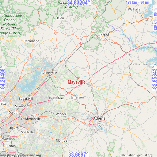
Maysville GPS coordinates[2]
34° 15' 10.368" North, 83° 33' 41.58" West
| Map corner | latitude | longitude |
|---|---|---|
| Upper-left | 34.83204°, | -84.26468° |
| Center: | 34.25288°, | -83.56155° |
| Lower-right: | 33.6697°, | -82.85843° |
| Map W x H: | 129.2×129.2 km | = 80.3×80.3mi |
| max Lat: | 71.29058° ⇑78.7% North |
| Maysville: | 34.25288° |
| min Lat: | ⇓21.3% South 19.06759° |
| min Long | Maysville | max Long |
| -171.73463° | -83.56155° | -66.98998° |
| W 60.4%⇐ | ⇒39.6% E |
Elevation
Elevation of Maysville is 274 m = 899 ft, and this is 20.8 m = 68 ft below average elevation for this country.
| Max E: |
3189 m = 10463 ft | 32.4% |
| Avg. | 294.8 m = 967 ft | |
| Maysville | 274 m = 899 ft | |
Min E: |
-60 m = -197 ft | 67.6% |
See also: United States elevation on elevation.city.
Geographical zone
Maysville is located in North temperate zone (between Tropic of Cancer and the Arctic Circle). Distance of this Northern Tropic circle is 1202.6 km =747.3 mi to South.| Distance of | km | miles | from Maysville |
|---|---|---|---|
| North Pole | 6198.5 | 3851.6 | to North |
| Arctic Circle | 3592.6 | 2232.3 | to North |
| Tropic Cancer | 1202.6 | 747.3 | to South |
| Equator | 3808.6 | 2366.6 | to South |


Nearby cities:
15 places around Maysville: (largest is in red/bold)
• Alto
23.9 km =14.9 mi,  357°
357°
• Arcade
19.5 km =12.1 mi,  180°
180°
• Baldwin
26.7 km =16.6 mi,  4°
4°
• Braselton
24.4 km =15.2 mi,  229°
229°
• Commerce
11 km =6.8 mi,  119°
119°
• Cornelia
28.9 km =18 mi,  6°
6°
• Gainesville
24.6 km =15.3 mi,  281°
281°
• Homer
10.7 km =6.6 mi,  32°
32°
• Hoschton
25.3 km =15.7 mi, 226°
• Jefferson
15.1 km =9.4 mi, 183°
• Lula
17.8 km =11.1 mi,  327°
327°
• Mount Airy
30.1 km =18.7 mi, 10°
• Nicholson
19.5 km =12.1 mi,  142°
142°
• Oakwood
29.8 km =18.5 mi,  264°
264°
• Raoul
22.1 km =13.7 mi,  352°
352°
Sources, notices
• [Note1] Compared only with cities in United States existing in our database
• [Src1] Map data: © OpenStreetMap contributors (CC-BY-SA)
• [Src2] Other city data from geonames.org with taken over terms of usage.
• [Src3] Geographical zone / Annual Mean Temperature by Robert A. Rohde @ Wikipedia
