Jefferson geodata
Jefferson (Georgia) is a seat of a second-order administrative division; located in United States in America/New_York (GMT-4) time zone. With population of 10,195 people, there are 4403 cities with bigger population in this country. Compared to other cities in United States, 79.5% of cities are located further ↑North; 60.4% of cities are located further ←West and 57.5% of cities have lower elevation than Jefferson. Note1


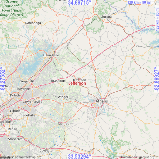
Jefferson GPS coordinates[2]
34° 7' 1.38" North, 83° 34' 20.604" West
| Map corner | latitude | longitude |
|---|---|---|
| Upper-left | 34.69715°, | -84.27552° |
| Center: | 34.11705°, | -83.57239° |
| Lower-right: | 33.53294°, | -82.86927° |
| Map W x H: | 129.4×129.4 km | = 80.4×80.4mi |
| max Lat: | 71.29058° ⇑79.5% North |
| Jefferson: | 34.11705° |
| min Lat: | ⇓20.5% South 19.06759° |
| min Long | Jefferson | max Long |
| -171.73463° | -83.57239° | -66.98998° |
| W 60.4%⇐ | ⇒39.6% E |
Elevation
Elevation of Jefferson is 228 m = 748 ft, and this is 66.8 m = 219 ft below average elevation for this country.
| Max E: |
3189 m = 10463 ft | 42.5% |
| Avg. | 294.8 m = 967 ft | |
| Jefferson | 228 m = 748 ft | |
Min E: |
-60 m = -197 ft | 57.5% |
See also: United States elevation on elevation.city.
Geographical zone
Jefferson is located in North temperate zone (between Tropic of Cancer and the Arctic Circle). Distance of this Northern Tropic circle is 1187.5 km =737.9 mi to South.| Distance of | km | miles | from Jefferson |
|---|---|---|---|
| North Pole | 6213.6 | 3861 | to North |
| Arctic Circle | 3607.7 | 2241.7 | to North |
| Tropic Cancer | 1187.5 | 737.9 | to South |
| Equator | 3793.5 | 2357.2 | to South |


Nearby cities:
15 places around Jefferson: (largest is in red/bold)
• Arcade
4.5 km =2.8 mi,  167°
167°
• Athens
24.9 km =15.5 mi,  134°
134°
• Auburn
26.2 km =16.3 mi,  243°
243°
• Bethlehem
24.3 km =15.1 mi,  212°
212°
• Bogart
19 km =11.8 mi, 169°
• Braselton
17.5 km =10.9 mi,  267°
267°
• Commerce
14.4 km =8.9 mi,  47°
47°
• Country Club Estates
20.7 km =12.9 mi, 133°
• Homer
25 km =15.5 mi,  15°
15°
• Hoschton
17.5 km =10.9 mi,  262°
262°
• Maysville
15.1 km =9.4 mi,  3°
3°
• Nicholson
13 km =8.1 mi,  91°
91°
• Russell
19.4 km =12.1 mi,  217°
217°
• Statham
17 km =10.6 mi,  187°
187°
• Winder
19.4 km =12.1 mi, 224°
Sources, notices
• [Note1] Compared only with cities in United States existing in our database
• [Src1] Map data: © OpenStreetMap contributors (CC-BY-SA)
• [Src2] Other city data from geonames.org with taken over terms of usage.
• [Src3] Geographical zone / Annual Mean Temperature by Robert A. Rohde @ Wikipedia
