Oakwood geodata
Oakwood (Georgia) is a populated place; located in United States in America/New_York (GMT-4) time zone. With population of 4,178 people, there are 8017 cities with bigger population in this country. Compared to other cities in United States, 78.8% of cities are located further ↑North; 59.6% of cities are located further ←West and 79.8% of cities have lower elevation than Oakwood. Note1


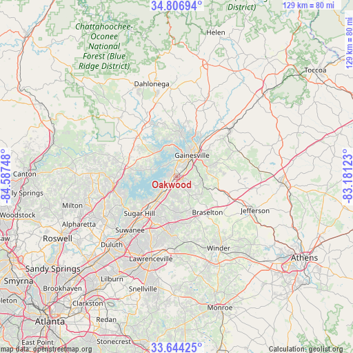
Oakwood GPS coordinates[2]
34° 13' 39.36" North, 83° 53' 3.66" West
| Map corner | latitude | longitude |
|---|---|---|
| Upper-left | 34.80694°, | -84.58748° |
| Center: | 34.2276°, | -83.88435° |
| Lower-right: | 33.64425°, | -83.18123° |
| Map W x H: | 129.3×129.3 km | = 80.3×80.3mi |
| max Lat: | 71.29058° ⇑78.8% North |
| Oakwood: | 34.2276° |
| min Lat: | ⇓21.2% South 19.06759° |
| min Long | Oakwood | max Long |
| -171.73463° | -83.88435° | -66.98998° |
| W 59.6%⇐ | ⇒40.4% E |
Elevation
Elevation of Oakwood is 351 m = 1152 ft, and this is 56.2 m = 184 ft above average elevation for this country.
| Max E: |
3189 m = 10463 ft | 20.2% |
| Oakwood | 351 m 1152 ft | |
| Avg. | 294.8 m = 967 ft | |
Min E: |
-60 m = -197 ft | 79.8% |
See also: United States elevation on elevation.city.
Geographical zone
Oakwood is located in North temperate zone (between Tropic of Cancer and the Arctic Circle). Distance of this Northern Tropic circle is 1199.8 km =745.5 mi to South.| Distance of | km | miles | from Oakwood |
|---|---|---|---|
| North Pole | 6201.3 | 3853.3 | to North |
| Arctic Circle | 3595.4 | 2234.1 | to North |
| Tropic Cancer | 1199.8 | 745.5 | to South |
| Equator | 3805.8 | 2364.8 | to South |


Nearby cities:
15 places around Oakwood: (largest is in red/bold)
• Auburn
24.3 km =15.1 mi,  167°
167°
• Braselton
17.3 km =10.7 mi,  139°
139°
• Buford
16.2 km =10.1 mi,  222°
222°
• Clermont
29.6 km =18.4 mi,  20°
20°
• Cumming
23.6 km =14.7 mi,  264°
264°
• Dacula
26.6 km =16.5 mi,  182°
182°
• Dawsonville
30.5 km =19 mi,  314°
314°
• Flowery Branch
6 km =3.7 mi, 218°
• Gainesville
9.6 km =6 mi,  35°
35°
• Hoschton
18.5 km =11.5 mi, 142°
• Lula
26.8 km =16.7 mi,  48°
48°
• Maysville
29.8 km =18.5 mi,  84°
84°
• Sugar Hill
19.2 km =11.9 mi,  225°
225°
• Suwanee
26.1 km =16.2 mi, 221°
• Winder
30.2 km =18.8 mi,  149°
149°
Sources, notices
• [Note1] Compared only with cities in United States existing in our database
• [Src1] Map data: © OpenStreetMap contributors (CC-BY-SA)
• [Src2] Other city data from geonames.org with taken over terms of usage.
• [Src3] Geographical zone / Annual Mean Temperature by Robert A. Rohde @ Wikipedia
