Moultrie geodata
Moultrie (Georgia) is a seat of a second-order administrative division; located in United States in America/New_York (GMT-4) time zone. With population of 14,377 people, there are 3362 cities with bigger population in this country. Compared to other cities in United States, 90.4% of cities are located further ↑North; 59.9% of cities are located further ←West and 69.7% of cities have higher elevation than Moultrie. Note1


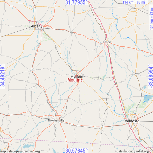
Moultrie GPS coordinates[2]
31° 10' 47.676" North, 83° 47' 20.616" West
| Map corner | latitude | longitude |
|---|---|---|
| Upper-left | 31.77955°, | -84.49219° |
| Center: | 31.17991°, | -83.78906° |
| Lower-right: | 30.57645°, | -83.08594° |
| Map W x H: | 133.8×133.8 km | = 83.1×83.1mi |
| max Lat: | 71.29058° ⇑90.4% North |
| Moultrie: | 31.17991° |
| min Lat: | ⇓9.6% South 19.06759° |
| min Long | Moultrie | max Long |
| -171.73463° | -83.78906° | -66.98998° |
| W 59.9%⇐ | ⇒40.1% E |
Elevation
Elevation of Moultrie is 102 m = 335 ft, and this is 192.8 m = 633 ft below average elevation for this country.
| Max E: |
3189 m = 10463 ft | 69.7% |
| Avg. | 294.8 m = 967 ft | |
| Moultrie | 102 m = 335 ft | |
Min E: |
-60 m = -197 ft | 30.3% |
See also: United States elevation on elevation.city.
Geographical zone
Moultrie is located in North temperate zone (between Tropic of Cancer and the Arctic Circle). Distance of this Northern Tropic circle is 861 km =535 mi to South.| Distance of | km | miles | from Moultrie |
|---|---|---|---|
| North Pole | 6540.2 | 4063.9 | to North |
| Arctic Circle | 3934.3 | 2444.7 | to North |
| Tropic Cancer | 861 | 535 | to South |
| Equator | 3466.9 | 2154.2 | to South |


Nearby cities:
15 places around Moultrie: (largest is in red/bold)
• Adel
35 km =21.7 mi,  97°
97°
• Berlin
20 km =12.4 mi,  128°
128°
• Coolidge
20.1 km =12.5 mi,  201°
201°
• Doerun
19.7 km =12.2 mi,  321°
321°
• Lenox
32.5 km =20.2 mi,  71°
71°
• Meigs
31 km =19.3 mi,  247°
247°
• Morven
38.3 km =23.8 mi, 133°
• Norman Park
13.9 km =8.6 mi,  44°
44°
• Ochlocknee
34.1 km =21.2 mi,  227°
227°
• Omega
25.8 km =16 mi,  46°
46°
• Pavo
24.9 km =15.5 mi,  168°
168°
• Pelham
35.1 km =21.8 mi,  260°
260°
• Poulan
37 km =23 mi,  0°
0°
• Sparks
33.5 km =20.8 mi,  92°
92°
• Ty Ty
35.2 km =21.9 mi,  22°
22°
Sources, notices
• [Note1] Compared only with cities in United States existing in our database
• [Src1] Map data: © OpenStreetMap contributors (CC-BY-SA)
• [Src2] Other city data from geonames.org with taken over terms of usage.
• [Src3] Geographical zone / Annual Mean Temperature by Robert A. Rohde @ Wikipedia
