Morven geodata
Morven (Georgia) is a populated place; located in United States in America/New_York (GMT-4) time zone. With population of 532 people, there are 20473 cities with bigger population in this country. Compared to other cities in United States, 90.8% of cities are located further ↑North; 60.6% of cities are located further ←West and 75.1% of cities have higher elevation than Morven. Note1


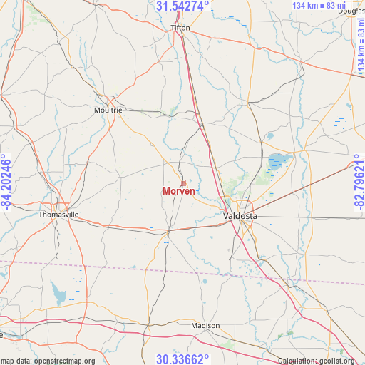
Morven GPS coordinates[2]
30° 56' 29.688" North, 83° 29' 57.588" West
| Map corner | latitude | longitude |
|---|---|---|
| Upper-left | 31.54274°, | -84.20246° |
| Center: | 30.94158°, | -83.49933° |
| Lower-right: | 30.33662°, | -82.79621° |
| Map W x H: | 134.1×134.1 km | = 83.3×83.3mi |
| max Lat: | 71.29058° ⇑90.8% North |
| Morven: | 30.94158° |
| min Lat: | ⇓9.2% South 19.06759° |
| min Long | Morven | max Long |
| -171.73463° | -83.49933° | -66.98998° |
| W 60.6%⇐ | ⇒39.4% E |
Elevation
Elevation of Morven is 71 m = 233 ft, and this is 223.8 m = 734 ft below average elevation for this country.
| Max E: |
3189 m = 10463 ft | 75.1% |
| Avg. | 294.8 m = 967 ft | |
| Morven | 71 m = 233 ft | |
Min E: |
-60 m = -197 ft | 24.9% |
See also: United States elevation on elevation.city.
Geographical zone
Morven is located in North temperate zone (between Tropic of Cancer and the Arctic Circle). Distance of this Northern Tropic circle is 834.5 km =518.5 mi to South.| Distance of | km | miles | from Morven |
|---|---|---|---|
| North Pole | 6566.7 | 4080.4 | to North |
| Arctic Circle | 3960.8 | 2461.1 | to North |
| Tropic Cancer | 834.5 | 518.5 | to South |
| Equator | 3440.4 | 2137.8 | to South |


Nearby cities:
15 places around Morven: (largest is in red/bold)
• Adel
22.9 km =14.2 mi,  18°
18°
• Berlin
18.4 km =11.4 mi,  319°
319°
• Boston
32.3 km =20.1 mi,  239°
239°
• Coolidge
35.8 km =22.2 mi,  282°
282°
• Dasher
34.3 km =21.3 mi,  129°
129°
• Hahira
13.3 km =8.3 mi,  65°
65°
• Lenox
36.8 km =22.9 mi,  5°
5°
• Moody A F B
27.3 km =17 mi,  81°
81°
• Nashville
37.9 km =23.5 mi,  38°
38°
• Pavo
22.8 km =14.2 mi, 275°
• Quitman
18.4 km =11.4 mi,  198°
198°
• Ray City
32.2 km =20 mi,  62°
62°
• Remerton
21 km =13 mi,  121°
121°
• Sparks
25.7 km =16 mi, 13°
• Valdosta
24.1 km =15 mi, 119°
Sources, notices
• [Note1] Compared only with cities in United States existing in our database
• [Src1] Map data: © OpenStreetMap contributors (CC-BY-SA)
• [Src2] Other city data from geonames.org with taken over terms of usage.
• [Src3] Geographical zone / Annual Mean Temperature by Robert A. Rohde @ Wikipedia
