Riceboro geodata
Riceboro (Georgia) is a populated place; located in United States in America/New_York (GMT-4) time zone. With population of 771 people, there are 18049 cities with bigger population in this country. Compared to other cities in United States, 89.1% of cities are located further ↑North; 68% of cities are located further ←West and 92.1% of cities have higher elevation than Riceboro. Note1


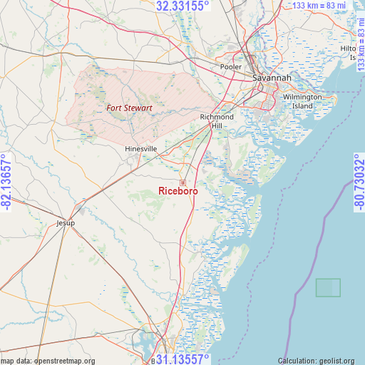
Riceboro GPS coordinates[2]
31° 44' 7.764" North, 81° 26' 0.384" West
| Map corner | latitude | longitude |
|---|---|---|
| Upper-left | 32.33155°, | -82.13657° |
| Center: | 31.73549°, | -81.43344° |
| Lower-right: | 31.13557°, | -80.73032° |
| Map W x H: | 133×133 km | = 82.6×82.6mi |
| max Lat: | 71.29058° ⇑89.1% North |
| Riceboro: | 31.73549° |
| min Lat: | ⇓10.9% South 19.06759° |
| min Long | Riceboro | max Long |
| -171.73463° | -81.43344° | -66.98998° |
| W 68%⇐ | ⇒32% E |
Elevation
Elevation of Riceboro is 12 m = 39 ft, and this is 282.8 m = 928 ft below average elevation for this country.
| Max E: |
3189 m = 10463 ft | 92.1% |
| Avg. | 294.8 m = 967 ft | |
| Riceboro | 12 m = 39 ft | |
Min E: |
-60 m = -197 ft | 7.9% |
See also: United States elevation on elevation.city.
Geographical zone
Riceboro is located in North temperate zone (between Tropic of Cancer and the Arctic Circle). Distance of this Northern Tropic circle is 922.7 km =573.3 mi to South.| Distance of | km | miles | from Riceboro |
|---|---|---|---|
| North Pole | 6478.4 | 4025.5 | to North |
| Arctic Circle | 3872.5 | 2406.3 | to North |
| Tropic Cancer | 922.7 | 573.3 | to South |
| Equator | 3528.7 | 2192.6 | to South |


Nearby cities:
15 places around Riceboro: (largest is in red/bold)
• Allenhurst
17.3 km =10.7 mi,  288°
288°
• Darien
40.6 km =25.2 mi,  180°
180°
• Flemington
18.5 km =11.5 mi,  318°
318°
• Fort Stewart
22.6 km =14 mi,  312°
312°
• Georgetown
33.7 km =20.9 mi,  35°
35°
• Henderson
34.5 km =21.4 mi,  28°
28°
• Hinesville
19.7 km =12.2 mi, 308°
• Isle of Hope
44.6 km =27.7 mi,  52°
52°
• Jesup
45.1 km =28 mi,  251°
251°
• Ludowici
29.4 km =18.3 mi,  264°
264°
• Midway
7.8 km =4.8 mi,  1°
1°
• Montgomery
37.2 km =23.1 mi, 52°
• Richmond Hill
25.7 km =16 mi, 28°
• Skidaway Island
42.7 km =26.5 mi,  58°
58°
• Walthourville
19.3 km =12 mi,  282°
282°
Sources, notices
• [Note1] Compared only with cities in United States existing in our database
• [Src1] Map data: © OpenStreetMap contributors (CC-BY-SA)
• [Src2] Other city data from geonames.org with taken over terms of usage.
• [Src3] Geographical zone / Annual Mean Temperature by Robert A. Rohde @ Wikipedia
