Walthourville geodata
Walthourville (Georgia) is a populated place; located in United States in America/New_York (GMT-4) time zone. With population of 3,974 people, there are 8250 cities with bigger population in this country. Compared to other cities in United States, 89.1% of cities are located further ↑North; 67% of cities are located further ←West and 83.6% of cities have higher elevation than Walthourville. Note1


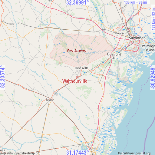
Walthourville GPS coordinates[2]
31° 46' 26.76" North, 81° 37' 57.396" West
| Map corner | latitude | longitude |
|---|---|---|
| Upper-left | 32.36991°, | -82.33574° |
| Center: | 31.7741°, | -81.63261° |
| Lower-right: | 31.17443°, | -80.92949° |
| Map W x H: | 132.9×132.9 km | = 82.6×82.6mi |
| max Lat: | 71.29058° ⇑89.1% North |
| Walthourville: | 31.7741° |
| min Lat: | ⇓10.9% South 19.06759° |
| min Long | Walthourville | max Long |
| -171.73463° | -81.63261° | -66.98998° |
| W 67%⇐ | ⇒33% E |
Elevation
Elevation of Walthourville is 33 m = 108 ft, and this is 261.8 m = 859 ft below average elevation for this country.
| Max E: |
3189 m = 10463 ft | 83.6% |
| Avg. | 294.8 m = 967 ft | |
| Walthourville | 33 m = 108 ft | |
Min E: |
-60 m = -197 ft | 16.4% |
See also: United States elevation on elevation.city.
Geographical zone
Walthourville is located in North temperate zone (between Tropic of Cancer and the Arctic Circle). Distance of this Northern Tropic circle is 927 km =576 mi to South.| Distance of | km | miles | from Walthourville |
|---|---|---|---|
| North Pole | 6474.1 | 4022.8 | to North |
| Arctic Circle | 3868.2 | 2403.6 | to North |
| Tropic Cancer | 927 | 576 | to South |
| Equator | 3532.9 | 2195.2 | to South |


Nearby cities:
15 places around Walthourville: (largest is in red/bold)
• Allenhurst
2.6 km =1.6 mi,  64°
64°
• Flemington
11.5 km =7.1 mi,  34°
34°
• Fort Stewart
11.1 km =6.9 mi,  11°
11°
• Georgetown
44.8 km =27.8 mi, 58°
• Glennville
33.3 km =20.7 mi,  302°
302°
• Henderson
43.8 km =27.2 mi,  53°
53°
• Hinesville
8.8 km =5.5 mi,  23°
23°
• Jesup
30.3 km =18.8 mi,  232°
232°
• Ludowici
12.7 km =7.9 mi, 234°
• Midway
19.4 km =12.1 mi,  79°
79°
• Odum
39.3 km =24.4 mi,  252°
252°
• Pembroke
40.3 km =25 mi,  1°
1°
• Riceboro
19.3 km =12 mi,  102°
102°
• Richmond Hill
36.1 km =22.4 mi, 59°
• Screven
48.5 km =30.1 mi, 228°
Sources, notices
• [Note1] Compared only with cities in United States existing in our database
• [Src1] Map data: © OpenStreetMap contributors (CC-BY-SA)
• [Src2] Other city data from geonames.org with taken over terms of usage.
• [Src3] Geographical zone / Annual Mean Temperature by Robert A. Rohde @ Wikipedia
