Tyrone geodata
Tyrone (Georgia) is a populated place; located in United States in America/New_York (GMT-4) time zone. With population of 7,194 people, there are 5703 cities with bigger population in this country. Compared to other cities in United States, 83.2% of cities are located further ↑North; 57% of cities are located further ←West and 72.6% of cities have lower elevation than Tyrone. Note1


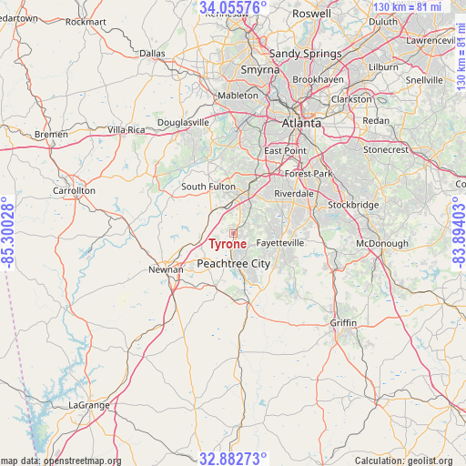
Tyrone GPS coordinates[2]
33° 28' 16.428" North, 84° 35' 49.74" West
| Map corner | latitude | longitude |
|---|---|---|
| Upper-left | 34.05576°, | -85.30028° |
| Center: | 33.47123°, | -84.59715° |
| Lower-right: | 32.88273°, | -83.89403° |
| Map W x H: | 130.4×130.4 km | = 81×81mi |
| max Lat: | 71.29058° ⇑83.2% North |
| Tyrone: | 33.47123° |
| min Lat: | ⇓16.8% South 19.06759° |
| min Long | Tyrone | max Long |
| -171.73463° | -84.59715° | -66.98998° |
| W 57%⇐ | ⇒43% E |
Elevation
Elevation of Tyrone is 299 m = 981 ft, and this is 4.2 m = 14 ft above average elevation for this country.
| Max E: |
3189 m = 10463 ft | 27.4% |
| Tyrone | 299 m 981 ft | |
| Avg. | 294.8 m = 967 ft | |
Min E: |
-60 m = -197 ft | 72.6% |
See also: United States elevation on elevation.city.
Geographical zone
Tyrone is located in North temperate zone (between Tropic of Cancer and the Arctic Circle). Distance of this Northern Tropic circle is 1115.7 km =693.3 mi to South.| Distance of | km | miles | from Tyrone |
|---|---|---|---|
| North Pole | 6285.4 | 3905.6 | to North |
| Arctic Circle | 3679.5 | 2286.3 | to North |
| Tropic Cancer | 1115.7 | 693.3 | to South |
| Equator | 3721.7 | 2312.6 | to South |


Nearby cities:
15 places around Tyrone: (largest is in red/bold)
• Bonanza
24.2 km =15 mi,  91°
91°
• Brooks
23.8 km =14.8 mi,  147°
147°
• Chattahoochee Hills
17.5 km =10.9 mi,  300°
300°
• East Newnan
21.4 km =13.3 mi,  231°
231°
• Fairburn
10.8 km =6.7 mi,  7°
7°
• Fayetteville
13.4 km =8.3 mi,  100°
100°
• Irondale
22.1 km =13.7 mi, 87°
• Jonesboro
23.2 km =14.4 mi,  76°
76°
• Newnan
21.3 km =13.2 mi,  241°
241°
• Palmetto
8.5 km =5.3 mi,  307°
307°
• Peachtree City
8.3 km =5.2 mi,  179°
179°
• Riverdale
20.4 km =12.7 mi,  56°
56°
• Senoia
19.2 km =11.9 mi,  167°
167°
• Shannon
14.1 km =8.8 mi,  121°
121°
• Union City
13.8 km =8.6 mi,  21°
21°
Sources, notices
• [Note1] Compared only with cities in United States existing in our database
• [Src1] Map data: © OpenStreetMap contributors (CC-BY-SA)
• [Src2] Other city data from geonames.org with taken over terms of usage.
• [Src3] Geographical zone / Annual Mean Temperature by Robert A. Rohde @ Wikipedia
