Senoia geodata
Senoia (Georgia) is a populated place; located in United States in America/New_York (GMT-4) time zone. With population of 4,073 people, there are 8132 cities with bigger population in this country. Compared to other cities in United States, 84% of cities are located further ↑North; 57.2% of cities are located further ←West and 68.2% of cities have lower elevation than Senoia. Note1


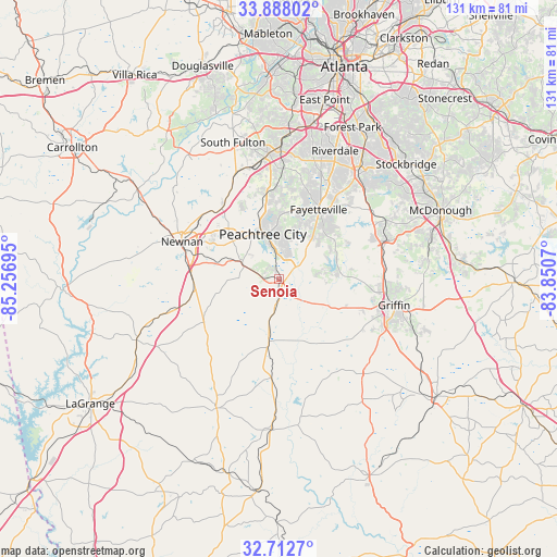
Senoia GPS coordinates[2]
33° 18' 8.424" North, 84° 33' 13.752" West
| Map corner | latitude | longitude |
|---|---|---|
| Upper-left | 33.88802°, | -85.25695° |
| Center: | 33.30234°, | -84.55382° |
| Lower-right: | 32.7127°, | -83.8507° |
| Map W x H: | 130.7×130.7 km | = 81.2×81.2mi |
| max Lat: | 71.29058° ⇑84% North |
| Senoia: | 33.30234° |
| min Lat: | ⇓16% South 19.06759° |
| min Long | Senoia | max Long |
| -171.73463° | -84.55382° | -66.98998° |
| W 57.2%⇐ | ⇒42.8% E |
Elevation
Elevation of Senoia is 277 m = 909 ft, and this is 17.8 m = 58 ft below average elevation for this country.
| Max E: |
3189 m = 10463 ft | 31.8% |
| Avg. | 294.8 m = 967 ft | |
| Senoia | 277 m = 909 ft | |
Min E: |
-60 m = -197 ft | 68.2% |
See also: United States elevation on elevation.city.
Geographical zone
Senoia is located in North temperate zone (between Tropic of Cancer and the Arctic Circle). Distance of this Northern Tropic circle is 1097 km =681.6 mi to South.| Distance of | km | miles | from Senoia |
|---|---|---|---|
| North Pole | 6304.2 | 3917.2 | to North |
| Arctic Circle | 3698.3 | 2298 | to North |
| Tropic Cancer | 1097 | 681.6 | to South |
| Equator | 3702.9 | 2300.9 | to South |


Nearby cities:
15 places around Senoia: (largest is in red/bold)
• Bonanza
27.1 km =16.8 mi,  47°
47°
• Brooks
8.9 km =5.5 mi,  98°
98°
• East Newnan
21.4 km =13.3 mi,  284°
284°
• Experiment
25.6 km =15.9 mi, 99°
• Fayetteville
18.7 km =11.6 mi,  29°
29°
• Grantville
27.3 km =17 mi,  254°
254°
• Hampton
26.9 km =16.7 mi,  69°
69°
• Irondale
26.8 km =16.7 mi,  42°
42°
• Lovejoy
26.8 km =16.7 mi,  56°
56°
• Luthersville
20.5 km =12.7 mi,  239°
239°
• Newnan
24.4 km =15.2 mi,  290°
290°
• Palmetto
26.3 km =16.3 mi,  335°
335°
• Peachtree City
11.2 km =7 mi, 339°
• Shannon
13.9 km =8.6 mi, 34°
• Tyrone
19.2 km =11.9 mi,  347°
347°
Sources, notices
• [Note1] Compared only with cities in United States existing in our database
• [Src1] Map data: © OpenStreetMap contributors (CC-BY-SA)
• [Src2] Other city data from geonames.org with taken over terms of usage.
• [Src3] Geographical zone / Annual Mean Temperature by Robert A. Rohde @ Wikipedia
