Walnut Grove geodata
Walnut Grove (Georgia) is a populated place; located in United States in America/New_York (GMT-4) time zone. With population of 1,378 people, there are 14219 cities with bigger population in this country. Compared to other cities in United States, 81.9% of cities are located further ↑North; 59.7% of cities are located further ←West and 69.5% of cities have lower elevation than Walnut Grove. Note1


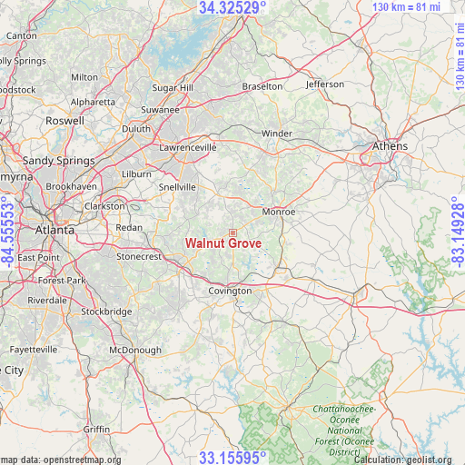
Walnut Grove GPS coordinates[2]
33° 44' 33.396" North, 83° 51' 8.64" West
| Map corner | latitude | longitude |
|---|---|---|
| Upper-left | 34.32529°, | -84.55553° |
| Center: | 33.74261°, | -83.8524° |
| Lower-right: | 33.15595°, | -83.14928° |
| Map W x H: | 130×130 km | = 80.8×80.8mi |
| max Lat: | 71.29058° ⇑81.9% North |
| Walnut Grove: | 33.74261° |
| min Lat: | ⇓18.1% South 19.06759° |
| min Long | Walnut Grove | max Long |
| -171.73463° | -83.8524° | -66.98998° |
| W 59.7%⇐ | ⇒40.3% E |
Elevation
Elevation of Walnut Grove is 283 m = 928 ft, and this is 11.8 m = 39 ft below average elevation for this country.
| Max E: |
3189 m = 10463 ft | 30.5% |
| Avg. | 294.8 m = 967 ft | |
| Walnut Grove | 283 m = 928 ft | |
Min E: |
-60 m = -197 ft | 69.5% |
See also: United States elevation on elevation.city.
Geographical zone
Walnut Grove is located in North temperate zone (between Tropic of Cancer and the Arctic Circle). Distance of this Northern Tropic circle is 1145.9 km =712 mi to South.| Distance of | km | miles | from Walnut Grove |
|---|---|---|---|
| North Pole | 6255.2 | 3886.8 | to North |
| Arctic Circle | 3649.3 | 2267.6 | to North |
| Tropic Cancer | 1145.9 | 712 | to South |
| Equator | 3751.8 | 2331.3 | to South |


Nearby cities:
15 places around Walnut Grove: (largest is in red/bold)
• Bethlehem
24.7 km =15.3 mi,  31°
31°
• Conyers
17.4 km =10.8 mi,  241°
241°
• Covington
16.2 km =10.1 mi,  182°
182°
• Grayson
19.4 km =12.1 mi,  330°
330°
• Lakeview Estates
17 km =10.6 mi,  256°
256°
• Lithonia
23.6 km =14.7 mi, 261°
• Loganville
11.6 km =7.2 mi,  337°
337°
• Monroe
14.1 km =8.8 mi,  65°
65°
• Oakwood
24.4 km =15.2 mi,  207°
207°
• Oxford
13.8 km =8.6 mi,  185°
185°
• Pine Mountain
25.4 km =15.8 mi,  253°
253°
• Porterdale
19 km =11.8 mi, 191°
• Rutledge
25.7 km =16 mi,  120°
120°
• Snellville
20.1 km =12.5 mi,  309°
309°
• Social Circle
15.7 km =9.8 mi,  127°
127°
Sources, notices
• [Note1] Compared only with cities in United States existing in our database
• [Src1] Map data: © OpenStreetMap contributors (CC-BY-SA)
• [Src2] Other city data from geonames.org with taken over terms of usage.
• [Src3] Geographical zone / Annual Mean Temperature by Robert A. Rohde @ Wikipedia
