Monroe geodata
Monroe (Georgia) is a seat of a second-order administrative division; located in United States in America/New_York (GMT-4) time zone. With population of 13,641 people, there are 3525 cities with bigger population in this country. Compared to other cities in United States, 81.6% of cities are located further ↑North; 60.1% of cities are located further ←West and 69.3% of cities have lower elevation than Monroe. Note1


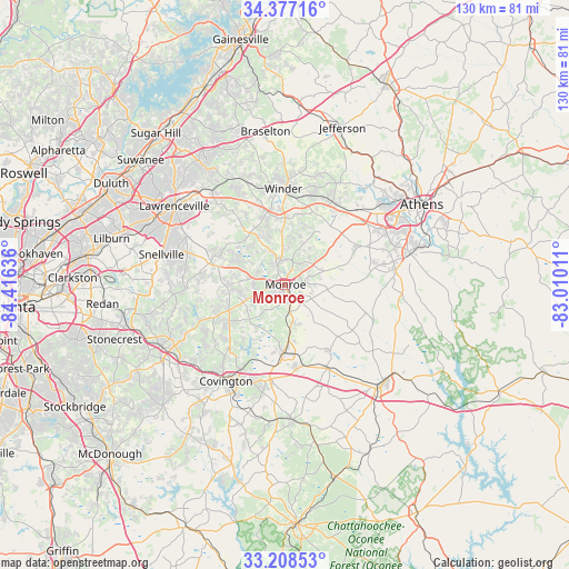
Monroe GPS coordinates[2]
33° 47' 41.424" North, 83° 42' 47.628" West
| Map corner | latitude | longitude |
|---|---|---|
| Upper-left | 34.37716°, | -84.41636° |
| Center: | 33.79484°, | -83.71323° |
| Lower-right: | 33.20853°, | -83.01011° |
| Map W x H: | 129.9×129.9 km | = 80.7×80.7mi |
| max Lat: | 71.29058° ⇑81.6% North |
| Monroe: | 33.79484° |
| min Lat: | ⇓18.4% South 19.06759° |
| min Long | Monroe | max Long |
| -171.73463° | -83.71323° | -66.98998° |
| W 60.1%⇐ | ⇒39.9% E |
Elevation
Elevation of Monroe is 282 m = 925 ft, and this is 12.8 m = 42 ft below average elevation for this country.
| Max E: |
3189 m = 10463 ft | 30.7% |
| Avg. | 294.8 m = 967 ft | |
| Monroe | 282 m = 925 ft | |
Min E: |
-60 m = -197 ft | 69.3% |
See also: United States elevation on elevation.city.
Geographical zone
Monroe is located in North temperate zone (between Tropic of Cancer and the Arctic Circle). Distance of this Northern Tropic circle is 1151.7 km =715.6 mi to South.| Distance of | km | miles | from Monroe |
|---|---|---|---|
| North Pole | 6249.4 | 3883.2 | to North |
| Arctic Circle | 3643.5 | 2264 | to North |
| Tropic Cancer | 1151.7 | 715.6 | to South |
| Equator | 3757.6 | 2334.9 | to South |


Nearby cities:
15 places around Monroe: (largest is in red/bold)
• Auburn
26.5 km =16.5 mi,  336°
336°
• Bethlehem
15.3 km =9.5 mi,  359°
359°
• Bogart
23.8 km =14.8 mi,  43°
43°
• Covington
25.9 km =16.1 mi,  211°
211°
• Dacula
27.5 km =17.1 mi,  321°
321°
• Grayson
25 km =15.5 mi,  296°
296°
• Loganville
18 km =11.2 mi,  285°
285°
• North High Shoals
19.4 km =12.1 mi,  81°
81°
• Oxford
24.2 km =15 mi,  216°
216°
• Russell
20.5 km =12.7 mi,  3°
3°
• Rutledge
21 km =13 mi,  153°
153°
• Social Circle
15.4 km =9.6 mi,  181°
181°
• Statham
21.8 km =13.5 mi,  29°
29°
• Walnut Grove
14.1 km =8.8 mi,  245°
245°
• Winder
22 km =13.7 mi, 358°
Sources, notices
• [Note1] Compared only with cities in United States existing in our database
• [Src1] Map data: © OpenStreetMap contributors (CC-BY-SA)
• [Src2] Other city data from geonames.org with taken over terms of usage.
• [Src3] Geographical zone / Annual Mean Temperature by Robert A. Rohde @ Wikipedia
