Rutledge geodata
Rutledge (Georgia) is a populated place; located in United States in America/New_York (GMT-4) time zone. With population of 793 people, there are 17876 cities with bigger population in this country. Compared to other cities in United States, 82.5% of cities are located further ↑North; 60.3% of cities are located further ←West and 54.9% of cities have lower elevation than Rutledge. Note1


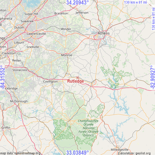
Rutledge GPS coordinates[2]
33° 37' 33.42" North, 83° 36' 44.604" West
| Map corner | latitude | longitude |
|---|---|---|
| Upper-left | 34.20943°, | -84.31552° |
| Center: | 33.62595°, | -83.61239° |
| Lower-right: | 33.03849°, | -82.90927° |
| Map W x H: | 130.2×130.2 km | = 80.9×80.9mi |
| max Lat: | 71.29058° ⇑82.5% North |
| Rutledge: | 33.62595° |
| min Lat: | ⇓17.5% South 19.06759° |
| min Long | Rutledge | max Long |
| -171.73463° | -83.61239° | -66.98998° |
| W 60.3%⇐ | ⇒39.7% E |
Elevation
Elevation of Rutledge is 218 m = 715 ft, and this is 76.8 m = 252 ft below average elevation for this country.
| Max E: |
3189 m = 10463 ft | 45.1% |
| Avg. | 294.8 m = 967 ft | |
| Rutledge | 218 m = 715 ft | |
Min E: |
-60 m = -197 ft | 54.9% |
See also: United States elevation on elevation.city.
Geographical zone
Rutledge is located in North temperate zone (between Tropic of Cancer and the Arctic Circle). Distance of this Northern Tropic circle is 1132.9 km =704 mi to South.| Distance of | km | miles | from Rutledge |
|---|---|---|---|
| North Pole | 6268.2 | 3894.9 | to North |
| Arctic Circle | 3662.3 | 2275.6 | to North |
| Tropic Cancer | 1132.9 | 704 | to South |
| Equator | 3738.9 | 2323.2 | to South |


Nearby cities:
15 places around Rutledge: (largest is in red/bold)
• Bethlehem
35.3 km =21.9 mi,  344°
344°
• Covington
23.2 km =14.4 mi,  261°
261°
• Jefferson
34.1 km =21.2 mi,  125°
125°
• Loganville
35.7 km =22.2 mi,  311°
311°
• Madison
13.8 km =8.6 mi,  104°
104°
• Monroe
21 km =13 mi,  333°
333°
• Monticello
36.3 km =22.6 mi,  190°
190°
• Newborn
14.4 km =8.9 mi,  212°
212°
• North High Shoals
23.7 km =14.7 mi,  24°
24°
• Oakwood
34.6 km =21.5 mi, 255°
• Oxford
23.6 km =14.7 mi,  268°
268°
• Porterdale
26.7 km =16.6 mi, 257°
• Social Circle
10.4 km =6.5 mi,  288°
288°
• Walnut Grove
25.7 km =16 mi,  300°
300°
• Watkinsville
32.4 km =20.1 mi,  35°
35°
Sources, notices
• [Note1] Compared only with cities in United States existing in our database
• [Src1] Map data: © OpenStreetMap contributors (CC-BY-SA)
• [Src2] Other city data from geonames.org with taken over terms of usage.
• [Src3] Geographical zone / Annual Mean Temperature by Robert A. Rohde @ Wikipedia
