Young Harris geodata
Young Harris (Georgia) is a populated place; located in United States in America/New_York (GMT-4) time zone. With population of 1,325 people, there are 14459 cities with bigger population in this country. Compared to other cities in United States, 75.8% of cities are located further ↑North; 59.7% of cities are located further ←West and 89.4% of cities have lower elevation than Young Harris. Note1


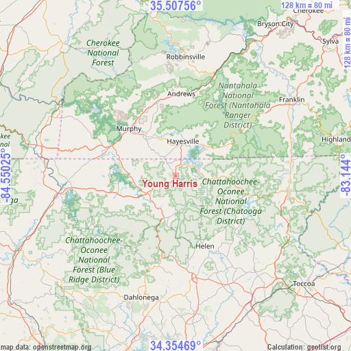
Young Harris GPS coordinates[2]
34° 55' 59.34" North, 83° 50' 49.632" West
| Map corner | latitude | longitude |
|---|---|---|
| Upper-left | 35.50756°, | -84.55025° |
| Center: | 34.93315°, | -83.84712° |
| Lower-right: | 34.35469°, | -83.144° |
| Map W x H: | 128.2×128.2 km | = 79.7×79.7mi |
| max Lat: | 71.29058° ⇑75.8% North |
| Young Harris: | 34.93315° |
| min Lat: | ⇓24.2% South 19.06759° |
| min Long | Young Harris | max Long |
| -171.73463° | -83.84712° | -66.98998° |
| W 59.7%⇐ | ⇒40.3% E |
Elevation
Elevation of Young Harris is 585 m = 1919 ft, and this is 290.2 m = 952 ft above average elevation for this country.
| Max E: |
3189 m = 10463 ft | 10.6% |
| Young Harris | 585 m 1919 ft | |
| Avg. | 294.8 m = 967 ft | |
Min E: |
-60 m = -197 ft | 89.4% |
See also: United States elevation on elevation.city.
Geographical zone
Young Harris is located in North temperate zone (between Tropic of Cancer and the Arctic Circle). Distance of this Northern Tropic circle is 1278.3 km =794.3 mi to South.| Distance of | km | miles | from Young Harris |
|---|---|---|---|
| North Pole | 6122.9 | 3804.6 | to North |
| Arctic Circle | 3517 | 2185.4 | to North |
| Tropic Cancer | 1278.3 | 794.3 | to South |
| Equator | 3884.2 | 2413.5 | to South |


Nearby cities:
15 places around Young Harris: (largest is in red/bold)
• Andrews
29.9 km =18.6 mi,  4°
4°
• Blairsville
11.9 km =7.4 mi,  237°
237°
• Blue Ridge
44.2 km =27.5 mi,  259°
259°
• Clarkesville
46.2 km =28.7 mi,  140°
140°
• Clayton
41.1 km =25.5 mi,  98°
98°
• Cleveland
38.1 km =23.7 mi,  168°
168°
• Dahlonega
46.3 km =28.8 mi,  195°
195°
• Hayesville
12.8 km =8 mi,  11°
11°
• Helen
27.8 km =17.3 mi,  157°
157°
• Hiawassee
8.4 km =5.2 mi,  77°
77°
• McCaysville
48.1 km =29.9 mi,  277°
277°
• Mountain City
42.1 km =26.2 mi,  92°
92°
• Murphy
24.2 km =15 mi,  315°
315°
• Robbinsville
43.5 km =27 mi, 4°
• Yonah
33.6 km =20.9 mi, 165°
Sources, notices
• [Note1] Compared only with cities in United States existing in our database
• [Src1] Map data: © OpenStreetMap contributors (CC-BY-SA)
• [Src2] Other city data from geonames.org with taken over terms of usage.
• [Src3] Geographical zone / Annual Mean Temperature by Robert A. Rohde @ Wikipedia
