Dahlonega geodata
Dahlonega (Georgia) is a seat of a second-order administrative division; located in United States in America/New_York (GMT-4) time zone. With population of 6,394 people, there are 6172 cities with bigger population in this country. Compared to other cities in United States, 77.5% of cities are located further ↑North; 59.3% of cities are located further ←West and 86% of cities have lower elevation than Dahlonega. Note1


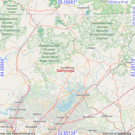
Dahlonega GPS coordinates[2]
34° 31' 57.324" North, 83° 59' 5.676" West
| Map corner | latitude | longitude |
|---|---|---|
| Upper-left | 35.10981°, | -84.68804° |
| Center: | 34.53259°, | -83.98491° |
| Lower-right: | 33.95134°, | -83.28179° |
| Map W x H: | 128.8×128.8 km | = 80×80mi |
| max Lat: | 71.29058° ⇑77.5% North |
| Dahlonega: | 34.53259° |
| min Lat: | ⇓22.5% South 19.06759° |
| min Long | Dahlonega | max Long |
| -171.73463° | -83.98491° | -66.98998° |
| W 59.3%⇐ | ⇒40.7% E |
Elevation
Elevation of Dahlonega is 444 m = 1457 ft, and this is 149.2 m = 490 ft above average elevation for this country.
| Max E: |
3189 m = 10463 ft | 14% |
| Dahlonega | 444 m 1457 ft | |
| Avg. | 294.8 m = 967 ft | |
Min E: |
-60 m = -197 ft | 86% |
See also: United States elevation on elevation.city.
Geographical zone
Dahlonega is located in North temperate zone (between Tropic of Cancer and the Arctic Circle). Distance of this Northern Tropic circle is 1233.7 km =766.6 mi to South.| Distance of | km | miles | from Dahlonega |
|---|---|---|---|
| North Pole | 6167.4 | 3832.2 | to North |
| Arctic Circle | 3561.5 | 2213 | to North |
| Tropic Cancer | 1233.7 | 766.6 | to South |
| Equator | 3839.7 | 2385.9 | to South |


Nearby cities:
15 places around Dahlonega: (largest is in red/bold)
• Alto
38.4 km =23.9 mi,  100°
100°
• Blairsville
38.3 km =23.8 mi,  3°
3°
• Clermont
20.3 km =12.6 mi,  107°
107°
• Cleveland
21.5 km =13.4 mi,  70°
70°
• Cumming
38.9 km =24.2 mi,  201°
201°
• Dawsonville
17.5 km =10.9 mi,  224°
224°
• Demorest
40.4 km =25.1 mi,  84°
84°
• Flowery Branch
39 km =24.2 mi,  171°
171°
• Gainesville
30 km =18.6 mi,  150°
150°
• Helen
29.8 km =18.5 mi,  50°
50°
• Lula
33.4 km =20.8 mi,  118°
118°
• Nelson
39.2 km =24.4 mi,  244°
244°
• Oakwood
35.1 km =21.8 mi,  164°
164°
• Raoul
37 km =23 mi, 104°
• Yonah
24.4 km =15.2 mi,  60°
60°
Sources, notices
• [Note1] Compared only with cities in United States existing in our database
• [Src1] Map data: © OpenStreetMap contributors (CC-BY-SA)
• [Src2] Other city data from geonames.org with taken over terms of usage.
• [Src3] Geographical zone / Annual Mean Temperature by Robert A. Rohde @ Wikipedia
